Indonesia counts 127 active volcanoes, and six of them define the classic volcano trip: Bromo, Ijen, Rinjani, Agung, Merapi and Semeru. They range from a one-hour sunrise walk to a three-day expedition. Two of the six are closed to summit climbers in October 2026. Here is how to choose, when to go and how to check that a mountain is safe before you set out.
Which Indonesian volcano should I climb?
For most first-time visitors the answer is Bromo for an easy sunrise and Ijen for a moderate night hike, both in East Java and easy to combine. Fit trekkers with three days should choose Rinjani on Lombok, and those based in Bali with one hard night to spare should look at Agung. Merapi and Semeru are best treated as viewing experiences in 2026, because their summits are closed.
The six differ less in height than in commitment: a 3 a.m. alarm and a short walk at Bromo, a gas mask and a 1 a.m. start at Ijen, a sleepless night on loose rock at Agung, two nights in a tent at Rinjani. Each has its own Journal guide, and every volcano has a profile on our volcanoes page.
How do the six volcanoes compare?
Bromo and the Merapi lava tour are easy, Ijen and the lower Semeru trail are moderate, and Agung and Rinjani are very hard. Days range from half a morning to three or four. The table below shows the essentials, including the status we could confirm in October 2026.
| Volcano | Height | Time needed | Difficulty | Best months | Status, Oct 2026 |
|---|---|---|---|---|---|
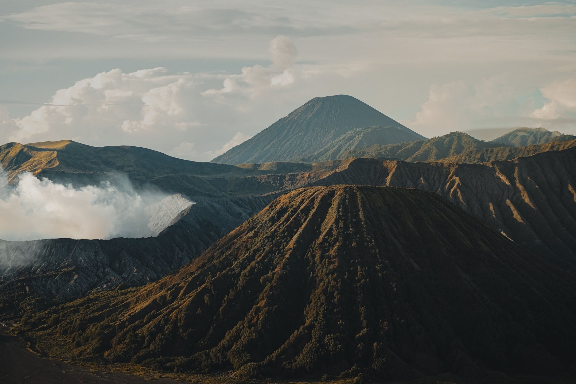
| Bromo (East Java) | 2,329 m | Half a day, sunrise | Easy | Dry season, about April to October | Open, but the Penanjakan viewpoint has been closed since 17 October 2026 because of a fire; Level II |
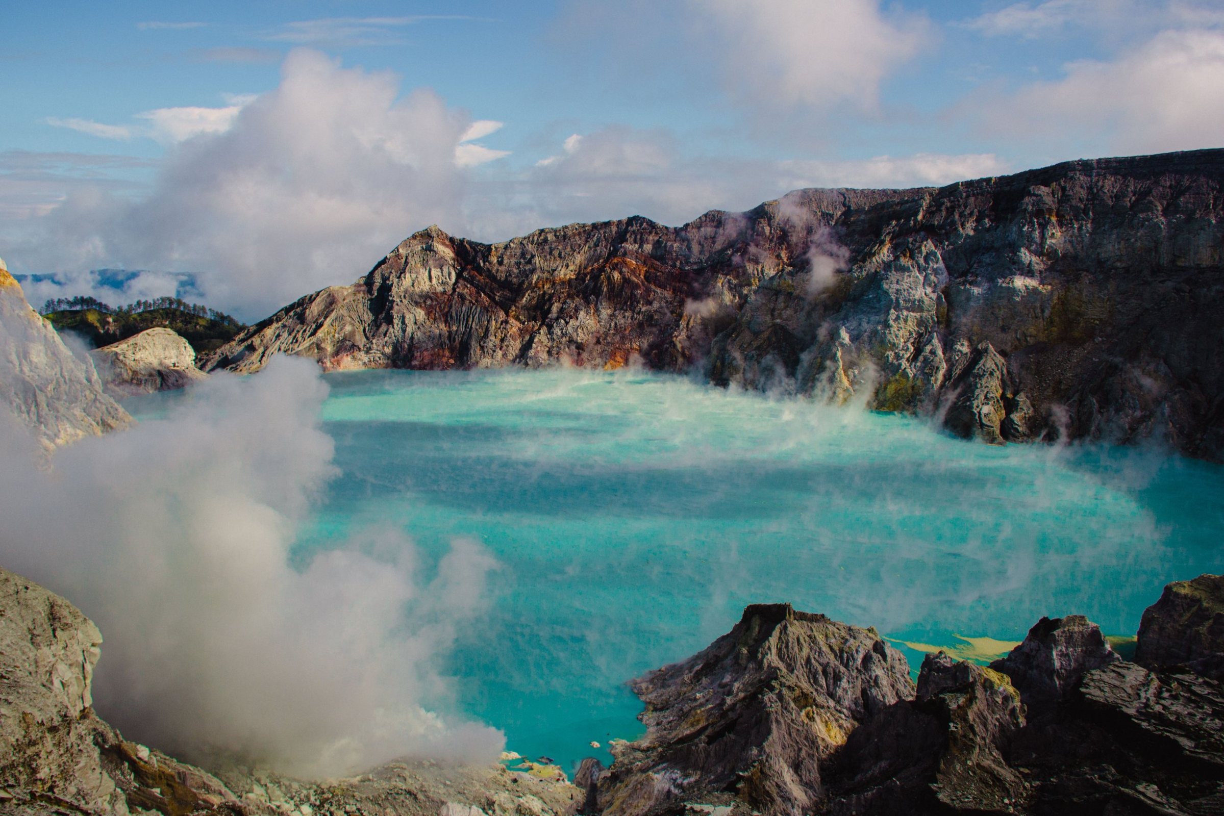
| Ijen (East Java) | 2,769 m (complex); rim about 2,350 m | One night, 5 to 6 hours | Moderate | Dry season, about April to October | Reopened 28 September 2026 after a fire closure |
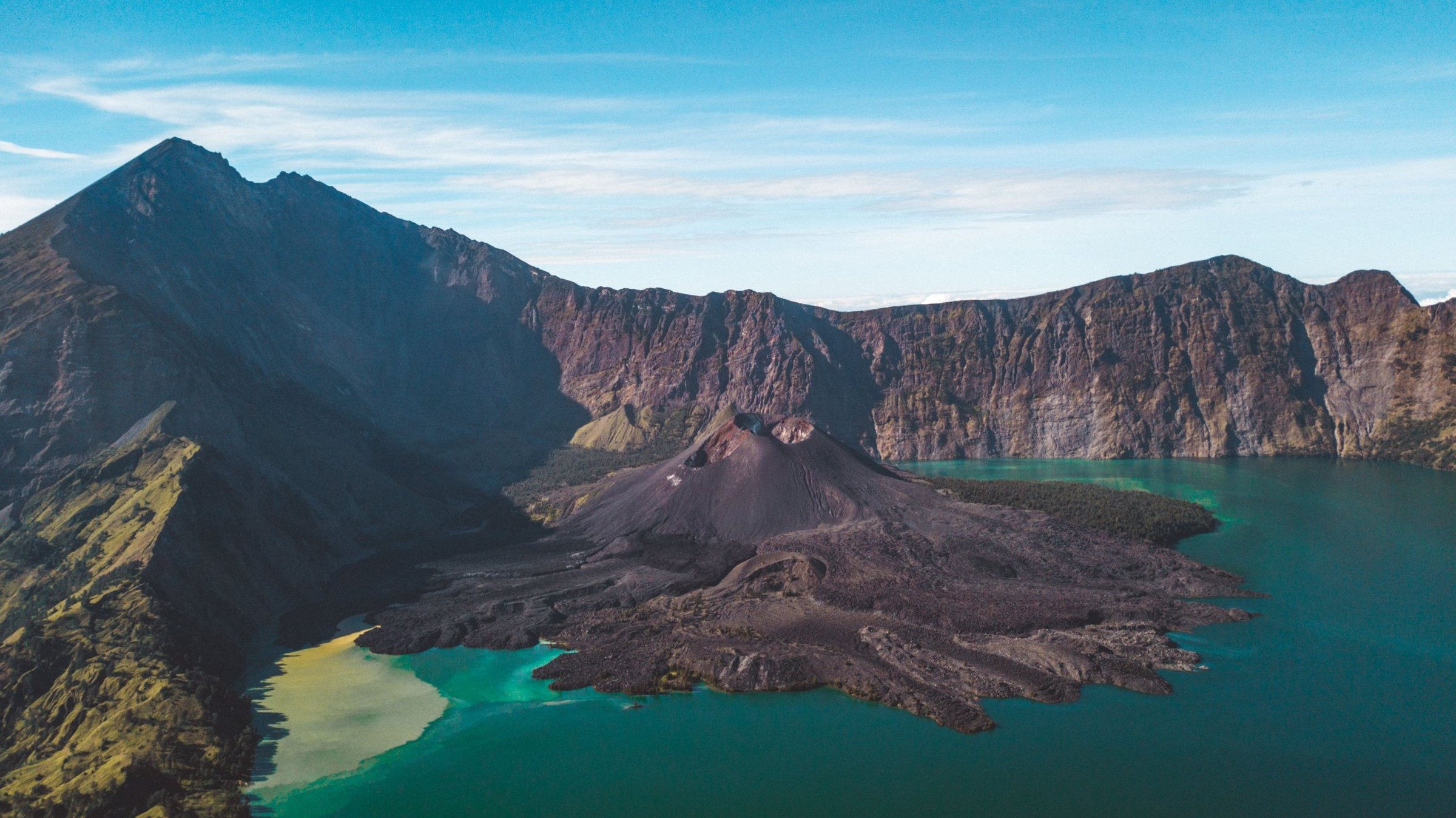
| Rinjani (Lombok) | 3,726 m | 2 to 4 days, 3 is classic | Very hard | Trails open about April to December; July to September clearest | Main routes open, Torean closed; Level II |
| Agung (Bali) | 2,997 m (Smithsonian) | One night: 6 to 8 hours or 11 to 12 hours | Very hard | About April or May to October | Reopened 25 April 2026 after a ceremony closure; check ceremony dates |
| Merapi (Central Java) | About 2,910 m | Half-day jeep tour | Easy (tour only) | Dry season, early mornings | Summit closed; Level III since November 2020 |
| Semeru (East Java) | 3,676 m | 2 days to Ranu Kumbolo when open | Moderate (lake trail) | Dry season, about April to October | All trails closed since a late-August 2026 fire; Level III |
Which volcano is best for beginners and families?
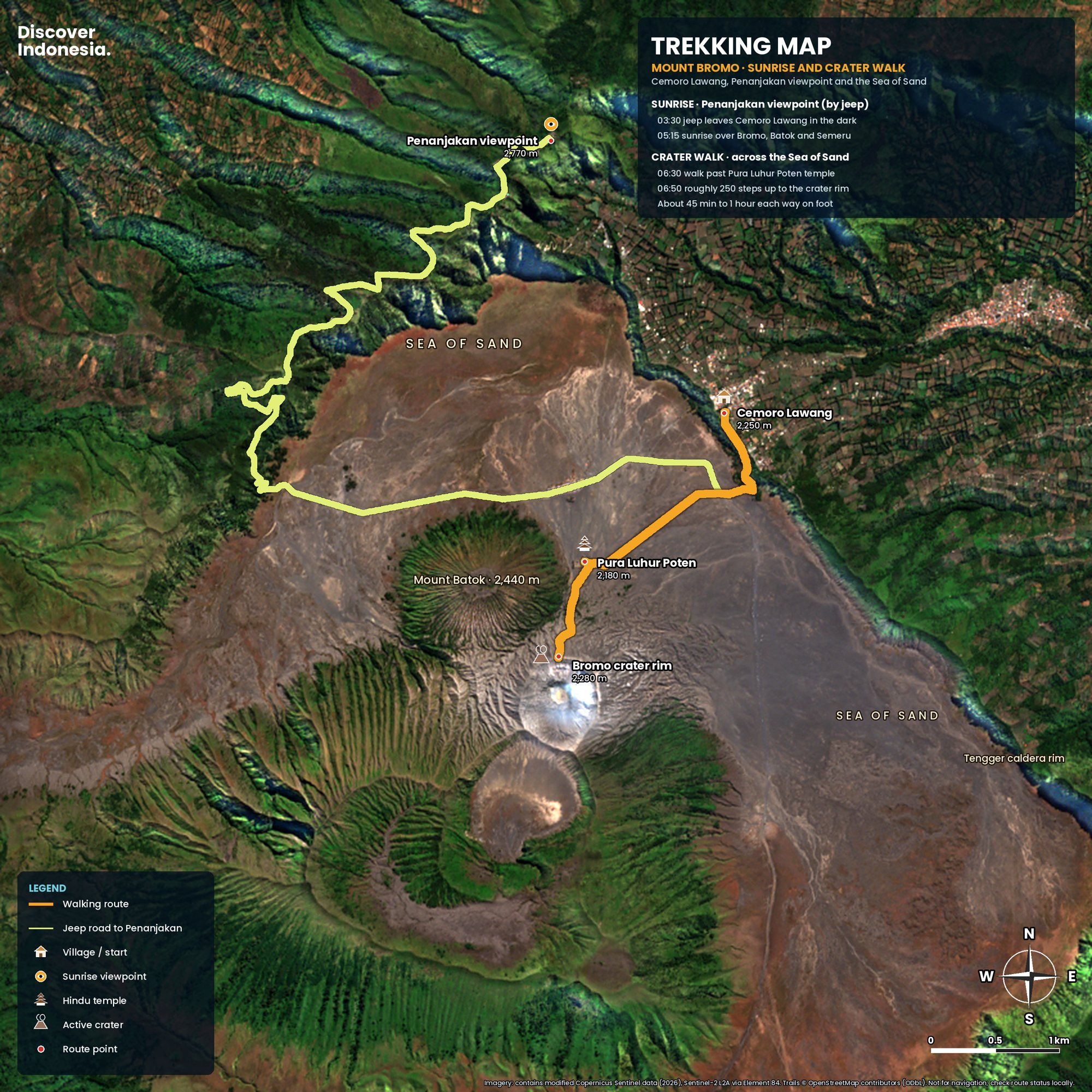
Bromo. The walk from Cemoro Lawang across the Sea of Sand to the crater takes about 45 minutes, followed by roughly 250 steep steps to the rim, and jeeps or hired horses can do most of the distance. The Merapi jeep tour above Yogyakarta is the other easy choice, with no hiking at all.
Most visitors first take a jeep in the dark to the Penanjakan viewpoint on the outer caldera rim, then drop into the caldera past the Tenggerese temple Pura Luhur Poten and walk to the rim. The full loop takes four to five hours. Pre-dawn temperatures can fall below 10°C, so even children need proper jackets. Our Mount Bromo sunrise guide covers viewpoints and timing in detail.
Merapi's lava tour starts from Kaliurang or Cangkringan, about an hour north of Yogyakarta, with open jeeps following the 2010 pyroclastic flows to the Kaliadem bunker and the Sisa Hartaku museum. See our Merapi lava tour guide.
Ijen is possible for older children and fit teenagers, but think hard about it. The crater fills with sulphur dioxide, which stings eyes and lungs, and the descent to the blue fire is steep and rocky. It is not a place for young children or anyone with asthma or heart or lung conditions.
Which volcano is best for photographers?
Bromo at sunrise and Ijen in the dark are the classic pair, and they are only one long day apart. Rinjani is the pick for a crater lake from above, and the Kaliadem bunker on the Merapi lava tour faces the summit at sunrise, when it is usually clearest.
Ijen's blue fire is sulphur-rich gas igniting as it escapes from cracks at up to 600°C. It burns all day but is visible only in full darkness, so photographers need to be at the lake edge before dawn and need a proper respirator, not a scarf. At first light the rim shows a turquoise lake that the Smithsonian describes as the world's largest body of hyperacidic brine. Read our Ijen blue fire guide before you go.
At Bromo, Penanjakan is normally the classic sunrise spot but is closed while the October 2026 fire is fought; Seruni Point and the Cemoro Lawang side are the alternatives. Clouds usually build by mid-morning on all of these mountains, so the light that matters comes early.
Which is the hardest volcano trek in Indonesia?
Of the six, Rinjani is the hardest overall because it combines altitude, multiple days and a summit on loose scree. Agung is the steepest single push, especially on the Besakih route to the true summit, which takes 11 to 12 hours round trip. Semeru's summit, Java's highest point, is a serious scree climb too, but it has been closed for long periods.
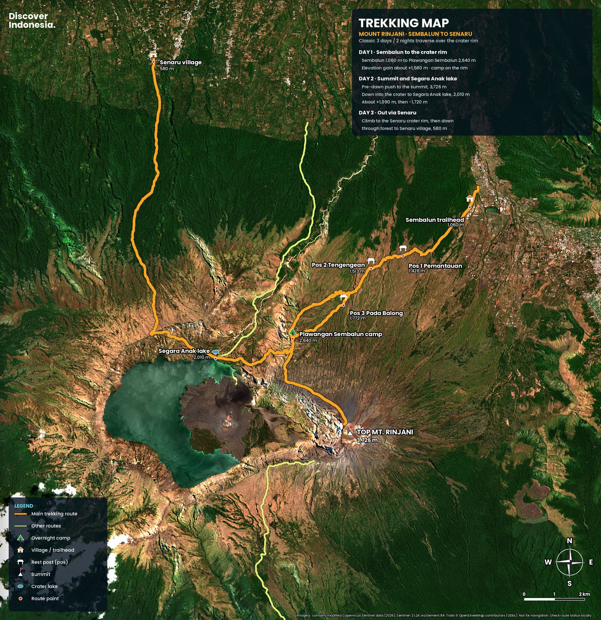
Rinjani's classic crossing climbs about 1,500 metres on the first day from Sembalun to the crater rim camp at roughly 2,640 metres. The summit push starts around 2 a.m. and gains another 1,000 metres or so, much of it on scree where every two steps up slide one back. Every trek is booked through the park's eRinjani system with a licensed operator, and guides and porters are mandatory. Our Rinjani guide answers the common questions.
Agung is done in one night. The Pasar Agung route reaches the southern crater rim, about 6 to 8 hours round trip; the Besakih route goes to the true summit. Both start around midnight, and a registered local guide is required. Tourists caught climbing without one have been deported. Details are in our Mount Agung climbing guide.
Are the volcanoes open in October 2026?
Bromo, Ijen and the main Rinjani routes are open, though at Bromo the Penanjakan viewpoint has been closed since 17 October because of a fire. Agung reopened in April after a ceremony closure, and we found no closure announced since, but confirm with your guide. Merapi's summit and every Semeru trail are closed. Fires during the 2026 dry season closed Bromo, Ijen and Semeru at different times, so recheck any booking.
Bromo
Fires that began on 3 August 2026 led Bromo Tengger Semeru National Park to close all tourist entrances to Bromo on the night of 8 August. The area reopened at one minute past midnight on 20 August, closed again for fire from 12 to 19 September, and since the evening of 17 October the park has stopped all traffic to the Penanjakan viewpoint on the Pasuruan side while a fire there is brought under control. On 15 October four members of a firefighting team died in the Mentigen and Pusung Lingker areas. Sunrise trips are running from Seruni Point and the Cemoro Lawang side. Tickets are sold through the official site, bromotenggersemeru.id, with a daily quota of 2,752 visitors. Bromo was at Level II, Waspada, in MAGMA's September 2026 list. The park also closes to tourists around the Tengger community's Yadnya Kasada ceremony each year.
Ijen
The East Java nature conservation agency, BBKSDA Jawa Timur, closed Ijen Crater Nature Park on 4 September 2026 during a forest fire emergency. It reopened on 28 September, with online ticket booking from 25 September. Visitors must carry a torch, a mask and warm clothing. Ijen did not appear among the volcanoes above Level I in early September 2026, but its gas hazard is constant, and access to the crater floor has been restricted in the past, for example when the alert rose to Level II in July 2024.
Rinjani
As of October 2026 the Sembalun, Senaru, Timbanuh, Tetebatu and Aik Berik routes are open and eRinjani bookings resumed on 3 October after a pause during the fire season. Torean remains closed. Rinjani was at Level II in September 2026, and all trails close every rainy season, usually from January to the end of March.
Agung
All activity on Agung was banned from 28 March to 24 April 2026 for the Ida Bhatara Turun Kabeh ceremonies at Besakih, and routes reopened on 25 April. Agung was not among the volcanoes above Level I in September 2026. Closures for ceremonies can be announced at short notice and sometimes last weeks, so check before booking.
Merapi
Official summit climbing has been closed since 2018, and the alert level has stood at Level III, Siaga, since 5 November 2020. In 2026 BPPTKG, the Yogyakarta volcano observatory, kept a danger zone of up to 7 kilometres along several south-southwest river valleys and 3 kilometres around the summit for explosions. The lava tour area on the southern slopes operates outside the danger zone.
Semeru
Semeru reached Level IV after pyroclastic flows in November 2025, and the trail closed entirely. It reopened on 24 April 2026 only as far as the lake of Ranu Kumbolo, with a local guide required. Around 26 August 2026 a forest fire on the mountain's savanna closed the route again, and no reopening date had been given. The volcano remained at Level III. Our Semeru and Ranu Kumbolo guide explains the route for when it reopens.
How do I check a volcano's alert level?
Use MAGMA Indonesia, the official volcano service of the Geological Agency, at magma.esdm.go.id or through its app. It shows each volcano's current level from I to IV, the latest observation reports and the recommended exclusion zone. Check it a few days before you travel and again on the day.
The four levels are defined in a regulation of Indonesia's Ministry of Energy and Mineral Resources:
- Level I, Normal: no visible or instrumental change. Daily life and normal activities continue.
- Level II, Waspada (alert): activity is rising and eruptions may occur, mainly threatening the area around the crater. People are usually told to stay out of a set radius from the vent. Bromo and Rinjani often sit here and can still be visited outside that radius.
- Level III, Siaga (standby): clear increase in activity; a larger eruption could follow. Avoid river valleys that start near the summit and be ready to evacuate. Summit trails are closed.
- Level IV, Awas (danger): an eruption is underway or likely within 24 hours, and danger may reach inhabited areas. People in the danger zone must evacuate.
Parks also close trails for fire, weather, ceremonies or ecosystem recovery, as Bromo did for a week in April 2026. So check both MAGMA and the park or conservation agency that runs the area: Bromo Tengger Semeru National Park, BBKSDA Jawa Timur for Ijen, Mount Rinjani National Park, and Mount Merapi National Park.
Can I combine Bromo and Ijen in one trip?
Yes, and it is the most popular volcano route in Indonesia. Bromo is reached from Probolinggo, with Cemoro Lawang on the caldera rim as the base. Ijen is near the eastern tip of Java, with Banyuwangi as the base and the Paltuding trailhead about an hour and a half away by road.
Arrive at Surabaya or Malang, sleep at Cemoro Lawang, do the Bromo sunrise, and spend the rest of the day driving east to the Ijen area. Sleep a few hours, leave around 1 a.m. for the roughly 3 kilometre trail from Paltuding to the rim, see the blue fire and the sunrise, and descend by mid-morning. From Banyuwangi the ferry from Ketapang crosses the Bali Strait to Gilimanuk, so the loop ends naturally in Bali. Allow three nights for this at minimum, four if you want to sleep properly between the two early starts.
Can I do Agung and Rinjani on the same trip?
Yes. Bali and Lombok sit next to each other, with short flights and boat services between them, so a Bali to Lombok route can include Batur or Agung on Bali and then Rinjani. Give your legs at least two or three days between Agung and Rinjani.
A sensible order is easiest first. Climb Batur as a warm-up, do Agung if it is open and no ceremony is on, then cross to Lombok for Rinjani. Rinjani's trails open around April, and the dry months from July to September are the clearest but the busiest, when permits can sell out. September is a good compromise. With about two weeks you can link everything: Bromo, Ijen, Batur or Agung, then Rinjani.
What about Batur, Kerinci and other volcanoes?
Mount Batur in Bali is the easiest real volcano climb in the country, a pre-dawn hike of one to two hours to a summit at about 1,717 metres. Kerinci in Sumatra, about 3,800 metres according to the Smithsonian and 3,805 metres in Indonesian sources, is Indonesia's highest volcano and a serious two-day climb.
Batur rises inside a double caldera, the outer one roughly 10 by 13.5 kilometres, with Lake Batur filling part of its floor. Its last eruption was in 2000. Hikers start around 4 a.m. to reach the top for sunrise over the lake and the caldera. It suits families with older children and anyone without the time or fitness for Agung.
Kerinci stands in the highlands of central Sumatra and rises 2,400 to 3,300 metres above the surrounding plains, with a summit crater about 600 metres wide. It was at Level II in September 2026 and suits experienced trekkers.
On Java, Merbabu is the usual hiking alternative to Merapi, with views across to it on clear days.
Why does Indonesia have so many volcanoes?
Because the edge of the Indian Ocean seafloor is sliding beneath Asia along the Sunda Arc, a chain about 3,000 kilometres long that runs through Sumatra, Java, Bali and the Lesser Sunda Islands. As that plate sinks, it melts and feeds magma to a line of volcanoes above it.
Indonesia's Geological Agency, Badan Geologi, counts 127 active volcanoes among roughly 500 volcanoes in the country, and monitors 69 of them in real time from 74 observation posts. The Smithsonian Global Volcanism Program, which uses a different definition based on activity in the past 12,000 years, lists 101 Holocene volcanoes for Indonesia in its country list, behind only the United States, Japan and Russia.
What sets Indonesia apart is how many people live close to active craters. Agung's 1963 eruption killed more than 1,000 people, and Merapi's in 2010 more than 350. Rinjani's caldera lake is the scar of Samalas, which collapsed in 1257 in one of the largest eruptions of the last several thousand years.
How do I stay safe on an Indonesian volcano?
Check MAGMA and the park's announcements, go with a licensed local guide, carry warm layers and a headlamp, and turn back when your guide or the weather says so. Respect every closed zone, however calm the crater looks.
- Cold: crater rims at dawn are far colder than the coast. Ijen's crater can drop to around 2 to 10°C, and Rinjani's rim camp to a few degrees above freezing.
- Gas: at Ijen, bring a proper respirator with filters and move away if the wind pushes fumes toward you. Carbon dioxide can pool in low ground.
- Falls: scree on Rinjani and loose rock on Agung cause more injuries than eruptions. Trekking poles and boots with ankle support help.
- Sudden explosions: Bromo's phreatic blast in June 2004 killed two tourists with little warning. Distance rules exist for a reason.
- Fire and respect: no campfires or cigarettes on the trail, and follow ceremony closures on sacred mountains.
Plan your volcano trip
Pick your base mountain first, then build around it. For an easy first taste, combine Bromo and Ijen in three or four nights from Surabaya and finish in Bali. For a fitness challenge, plan five days on Lombok around a three-day Rinjani crossing between April and December, and book early for July and August. For Bali-based travellers, Batur is a morning out, while Agung needs a free night, a licensed guide and a check on the Besakih ceremony calendar.
Stay close to the trailheads: Cemoro Lawang for Bromo, Banyuwangi for Ijen, Sembalun or Senaru for Rinjani, Kaliurang or Yogyakarta for Merapi. Keep a spare day in case weather, fire or an alert change pushes your climb back.
Our Discover Indonesia guides to Bromo, Ijen, Rinjani, Agung, Merapi and Semeru cover each mountain's routes, itineraries, where to stay and practical planning in more depth, and the volcano pages for Bromo, Ijen, Rinjani, Agung, Merapi and Semeru explain the geology and history behind each one.
Facts checked October 2026. Alert levels, fire and ceremony closures, quotas and permit rules change often; check MAGMA Indonesia and the relevant park (Bromo Tengger Semeru, BBKSDA Jawa Timur for Ijen, Rinjani or Merapi national parks) before you travel.
- Countries with Holocene Volcanoes (Smithsonian Global Volcanism Program)
- Kerinci (Smithsonian Global Volcanism Program)
- Batur (Smithsonian Global Volcanism Program)
- Bromo (Smithsonian Global Volcanism Program)
- Ijen (Smithsonian Global Volcanism Program)
- Rinjani (Smithsonian Global Volcanism Program)
- Badan Geologi: 127 Gunung Berapi di Indonesia Berstatus Aktif (CNN Indonesia)
- Status Gunung Api Hari Ini, 8 September 2026 (GoodStats, from MAGMA Indonesia data)
- 4 Macam Status Gunung Berapi (detikNews)
- Gunung Bromo Dibuka Kembali (CNA Indonesia)
- TNBTS sebut penutupan Bromo untuk pemulihan ekosistem (Antara)
- TWA Kawah Ijen Kembali Dibuka Pasca Kebakaran (Jawa Pos)
- TNBTS: Wisata Bromo Tetap Buka, Pendakian Semeru Ditutup Total (Metro TV)
- Mulai 24 April Gunung Semeru Dibuka Lagi (Metro TV)
- Mount Agung in Bali to Remain Closed for 28 Days (Travel Trade Journal)
- Status Gunung Merapi naik menjadi Siaga (Antara Jogja)
- Gunung Merapi Berstatus Siaga (Suara Surabaya)
- The 2010 explosive eruption of Java's Merapi volcano (USGS)
- Status G. Ijen Meningkat (Ministry of Energy and Mineral Resources)