In the dark before dawn, burning gas glows blue on the floor of a crater in eastern Java, beside the largest body of hyperacidic water on Earth. Kawah Ijen reopened on 28 September 2026 after a month of fire closures, with stricter booking and health rules than many older guides describe. This is what the night actually involves and how to plan it properly.
Is Kawah Ijen open right now?
Yes. Taman Wisata Alam Kawah Ijen, the nature recreation park around the crater, reopened to visitors on 28 September 2026. It had been closed since 4 September because of forest and land fires on the mountain. The park authority, BBKSDA Jawa Timur, reopened it for nature tourism and hiking after the emergency response ended and the trails were checked.
Two things matter for planning. First, the park now closes for a full day each month for "Ijen Rijik", a scheduled cleaning and conservation programme. The remaining dates on the official 2026 calendar are 6 November and 4 December. Second, the park states that it can close at any time for weather, volcanic activity, field conditions or management decisions. Check the official booking site and the alert level on MAGMA Indonesia, the government volcano monitoring service, a day or two before you go.
What is the blue fire at Ijen?
The blue fire is burning gas, not lava. Sulphur-rich gases escape from cracks on the crater floor at high pressure and at temperatures of up to about 600 °C. When they meet the oxygen in the air they ignite and burn with an electric blue flame, sometimes in tongues up to around five metres high.
Some of that gas condenses into liquid sulphur, which keeps burning as it trickles downhill. That is where the photographs of "blue lava" come from. Sulphur melts at only about 115 °C, and the vents are far hotter than that, so molten, glowing sulphur is common around them.
The flames burn around the clock but are too faint to see in daylight, which is why the hike happens at night. Be aware that the display is not a show. USGS geologist John Pallister told National Geographic he had heard that miners sometimes light sulphur themselves to boost the flames for night photographs, and the size of the fire varies from one night to the next. The park authority has said in the past that it promotes the crater, the lake and the sunrise, not the blue fire, so treat it as a possible bonus rather than a guarantee.
What makes the Ijen crater lake so unusual?
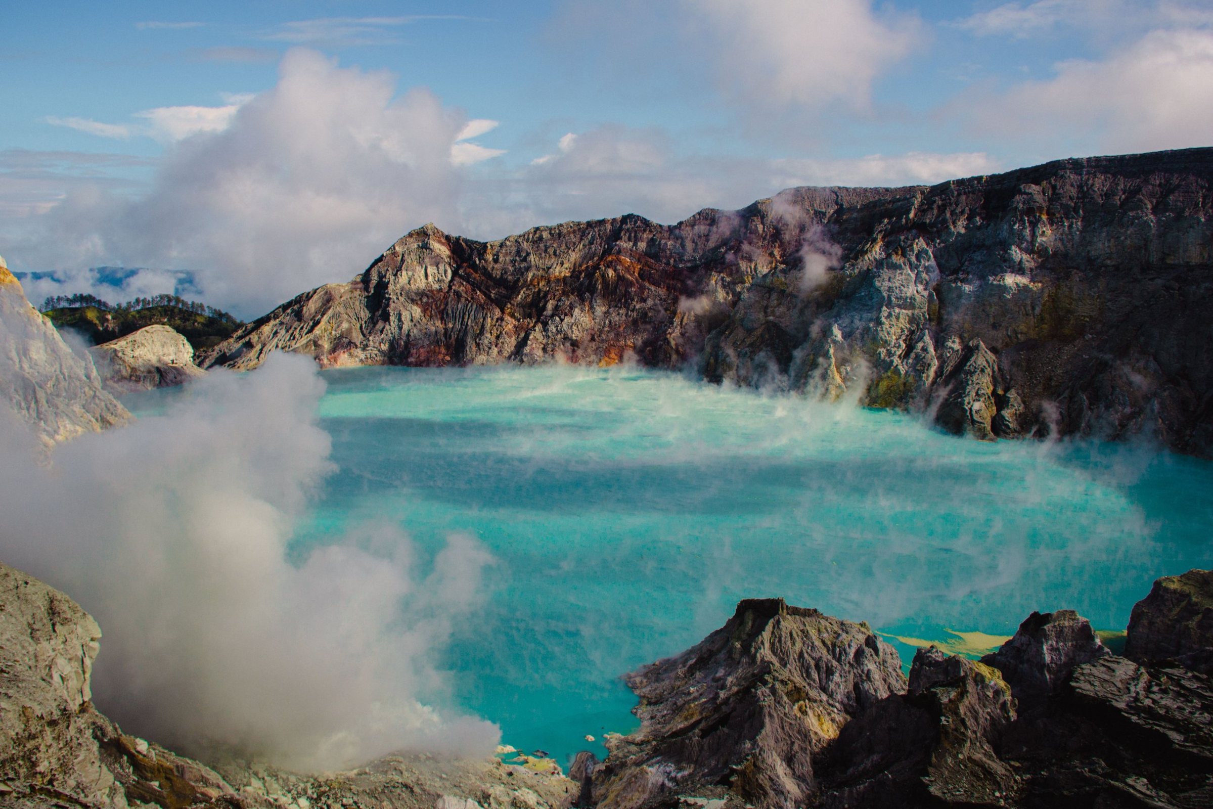
The milky turquoise lake inside Kawah Ijen is, in the words of the Smithsonian Institution's Global Volcanism Program, the largest body of natural hyperacidic brine in the world. It is roughly a kilometre across and around 200 metres deep, and measurements have recorded a pH close to zero, comparable to strong battery acid.
Indonesia's volcanology agency, PVMBG, has put its volume at about 30 million cubic metres. The water is warm: in August 2024 its surface measured about 42 °C, and sharp rises in lake temperature are one of the signals the agency watches. Steam-driven eruptions burst from the lake in 1993, 1994 and 1999, the last recorded eruptions. Since then Ijen has stirred mainly through gas, heat and periods of raised seismic activity.
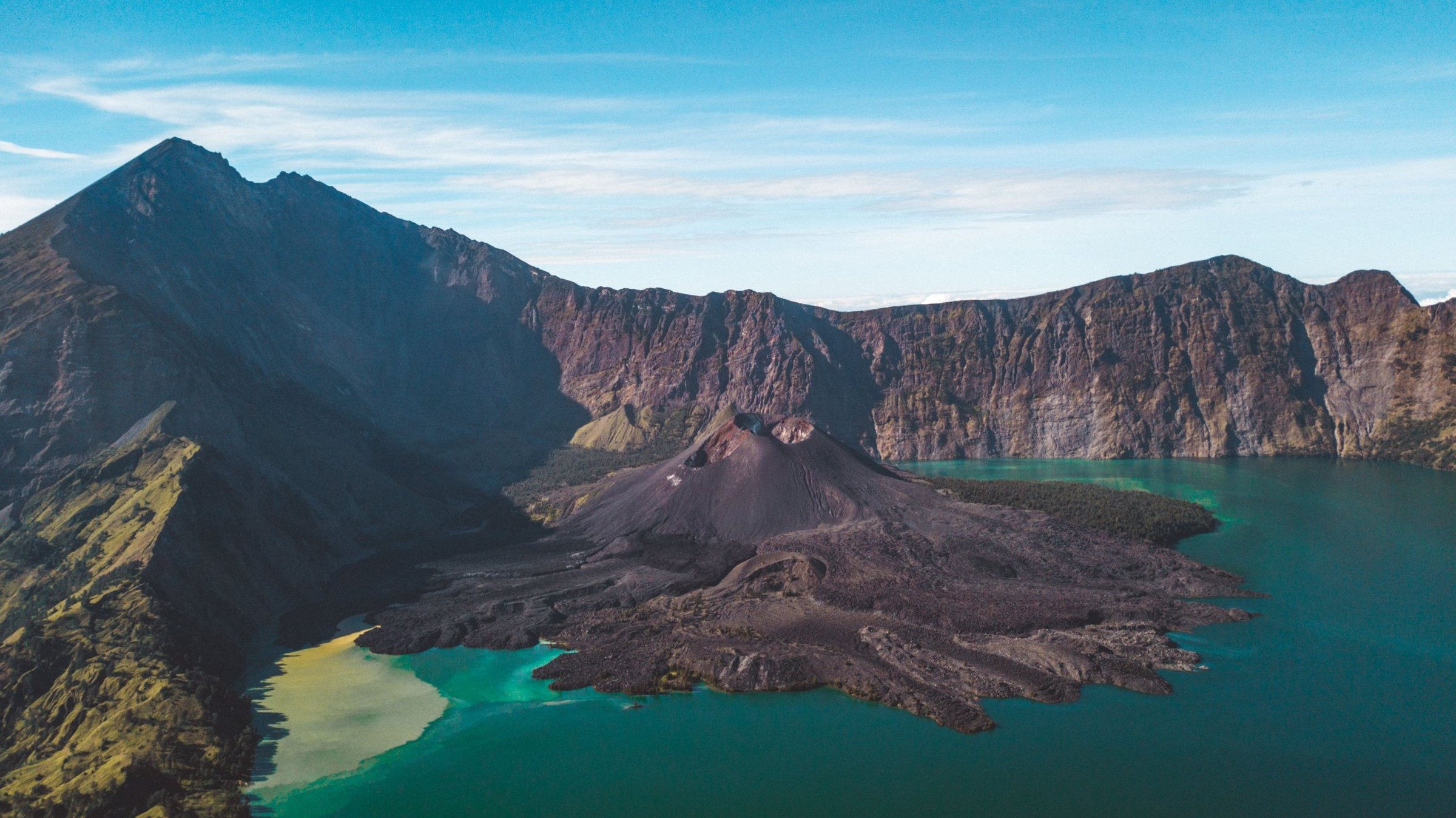
The setting is bigger than the crater. Ijen is a cluster of volcanoes inside an old caldera about 20 kilometres wide. Its highest point is not the crater rim at all but Gunung Merapi, at 2,769 metres according to the Global Volcanism Program (not to be confused with the better-known Merapi in Central Java). The crater rim you hike to sits well below that. The wider area became a UNESCO Global Geopark in 2023.
Who are the Ijen sulphur miners?
They are local men, mostly from villages at the foot of the volcano, who cut solidified sulphur from the crater floor and carry it out by hand. Ceramic pipes channel gas from the vents; the sulphur cools inside and around them into bright yellow crusts, which the miners break into chunks and load into a pair of baskets on a shoulder pole.
A typical load weighs 75 to 90 kilograms. It goes up the steep crater wall, about 300 metres of climbing on slopes of 45 to 60 degrees, then roughly 3 kilometres down the mountain to be weighed and paid for by weight. Many make the trip twice a day. Few have proper respirators, and small medical studies have linked the fumes to eroded teeth and gum disease.
On the trail you will pass the weighing post at Pondok Bunder, about two-thirds of the way up. Some miners sell small sulphur carvings to visitors. Etiquette is simple: step aside and give anyone carrying a load the right of way, especially on the narrow crater path, and ask before photographing someone up close.
How hard is the Ijen hike?
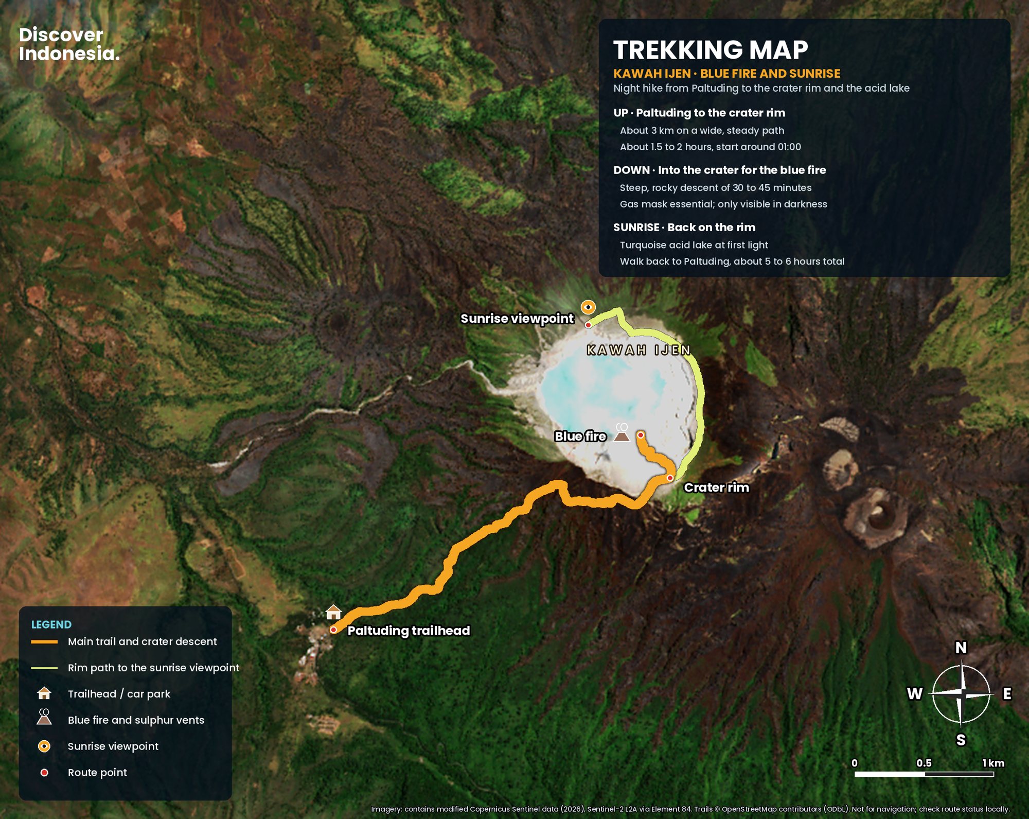
It is a moderate hike that most reasonably fit people can do. The trail from the Paltuding trailhead to the crater rim is about 3 kilometres on a wide, steady path with roughly 500 metres of climbing. Most people take one and a half to two hours to reach the rim, and a full night out, with the crater descent and sunrise, runs to about five or six hours.
The night, step by step
- Paltuding: the trailhead, ranger post and ticket check, with parking, warungs and toilets. Your online booking is exchanged for an entry ticket here.
- Paltuding to Pondok Bunder: about 2 kilometres, the steepest sustained section, on a broad sandy track through forest.
- Pondok Bunder to the rim: about 1 kilometre on an easier gradient, increasingly bare and sulphur-scented as you approach the crater.
- The descent: from the rim, a rough, rocky miners' path drops into the crater toward the vents and the lake shore. Allow 30 to 45 minutes down and longer back up.
- Sunrise: back on the rim, a path leads along the crater edge to higher viewpoints over the lake as the light comes up.
The descent is the hard part: uneven, steep, often in thick fumes, by headlamp, among miners carrying loads the other way. If the wind pushes the plume onto the path, visibility can drop to almost nothing within seconds.
Can you still walk down to the blue fire?
Sometimes, and it depends on the day. Even when Ijen is at Level I (Normal), PVMBG's standing recommendation has been that visitors, tourists and miners should not approach the crater rim closely or descend to the crater floor, and that nobody should stay overnight within 500 metres of the crater. When the alert level rises, as it did to Level II in July 2024, the crater floor is formally off limits.
In practice, guides take visitors down when park staff allow it, and turn back when they don't. Do not plan your trip around a descent you have read about in an old itinerary. Ask your guide on the night, follow the rangers, and if you are told the descent is closed, the rim and the sunrise over the lake are still worth the climb.
Do I need a gas mask at Ijen?
Yes, a proper one. A respirator with filters rated for acid gases is the minimum for the crater floor; a scarf, a buff or a surgical mask does very little against sulphur dioxide. Many guided trips include a mask, but if you rely on a supplied or rented one, check the filters are not spent before you set off.
The main hazard at Ijen is gas. Sulphur dioxide stings the eyes and lungs. The lake can also release carbon dioxide, which is invisible, heavier than air and pools in low ground. In March 2018 a gas release sent around 30 people from nearby villages for treatment. The crater walls are also dangerous: in April 2024 a visitor died after falling while posing for a photograph near the edge. Stay on the marked path, keep well back from drops, and turn back if the plume swings toward you.
Who should not hike Ijen?
The park says people with a history of heart disease, asthma, respiratory infections or other breathing disorders are not recommended to hike. Every visitor must be in good physical and mental condition and must bring a valid health certificate issued no more than three days before the visit date.
The health certificate is the rule that catches most foreign visitors out. It is checked when you exchange your booking for a ticket, and in 2024 local media reported that no clinic at Paltuding was issuing them, so get one before you arrive. Ask your hotel or tour operator in Banyuwangi where to get one in time. Rules on pregnancy and minimum age are not set out on the park's official page; if either applies to you, ask the park or your operator directly, and given the gas, talk to your doctor first.
Tickets do not include insurance, so make sure your own policy covers hiking.
What are Ijen's opening hours and how do I book?
The official hiking gate at Paltuding is open from 02:00 to 12:00 Western Indonesian Time (WIB). Tickets are sold online through the national parks platform, AyoKeTamanNasional, and the name on the booking must match your passport. Purchased tickets cannot be cancelled, rescheduled or refunded.
One detail trips up travellers from Bali every week: East Java runs on WIB, one hour behind Bali's Central Indonesian Time (WITA). A 02:00 gate in Java is 03:00 on a Bali clock. With the gate at 02:00 and about two hours to the rim, the window to see the blue fire before dawn is short, so be at Paltuding before the gate opens rather than after.
| Ijen at a glance | Details |
|---|---|
| Managed by | BBKSDA Jawa Timur (TWA Kawah Ijen) |
| Trailhead | Paltuding, Banyuwangi side |
| Hike | About 3 km to the rim, plus a rough descent into the crater |
| Gate | 02:00 to 12:00 WIB |
| Booking | Online, ID must match, non-refundable |
| Health | Certificate issued within 3 days of the visit |
| Monthly closures | Ijen Rijik days: 6 Nov and 4 Dec 2026 |
How do I get to Ijen from Banyuwangi?
Banyuwangi, on Java's far eastern tip, is the usual base. The drive up through Licin district to Paltuding takes roughly one to one and a half hours by car, climbing steeply through plantations and forest in the dark.
Banyuwangi has its own airport and train links along Java, with Ketapang station close to the Bali ferry harbour. Hiring a car with a driver for the night is easy to arrange through hotels and homestays.
Can you do Ijen from Bali?
Yes. Cross from Gilimanuk, at Bali's western tip, to Ketapang near Banyuwangi on the public car ferry across the Bali Strait. The crossing runs around the clock with frequent departures and takes about 45 minutes, although queues can add much more around weekends and holidays. Tickets are bought through ASDP's Ferizy app or website.
The catch is the drive across Bali to Gilimanuk, which from Canggu, Seminyak or Ubud takes several hours. Overnight tours from Bali mean a long drive, a ferry and a midnight hike with no real sleep. A better plan is to cross in the afternoon, sleep a few hours in Banyuwangi, hike, then rest before returning or continuing into Java. The crossing closes completely on Nyepi, Bali's day of silence, so avoid that date.
What about the Bondowoso side?
Ijen straddles two regencies, Banyuwangi to the east and Bondowoso to the west. The Bondowoso side is the high Ijen plateau, reached through the village of Sempol, with coffee plantations and the Blawan hot spring in Kalianyar village. The road from Sempol joins the Paltuding trailhead, so you hike the same route.
This side suits travellers coming from Bromo, Jember or further west in Java, and anyone who wants quiet nights in the highlands. The area grows the geographically certified Java Ijen-Raung Arabica, and the Jampit plantation is one of the large estates you can visit.
Where should I stay for Ijen?
There are three practical bases. Banyuwangi town has the widest choice of hotels and guesthouses, plus restaurants and transport, at the cost of a midnight start. Licin district and the villages on the lower slopes put you closer to the trailhead and cut the night drive. Sempol and Blawan on the Bondowoso plateau are cooler and quieter, with plantation guesthouses and homestays. There is basic accommodation near Paltuding itself, but expect simple rooms and cold nights.
Is a tour better than going independently?
A licensed local guide is strongly worth it for the crater descent, which is dark, steep and gassy, and guides know where the fumes are blowing. A tour from Banyuwangi usually bundles transport, guide, mask, ticket handling and help with the health certificate, which removes most of the friction.
Going independently works if you book online yourself, bring a health certificate, hire a driver for the night and engage a guide at Paltuding. Be wary of any package that guarantees the blue fire: nobody can promise the descent will be open.
When is the best time to visit Ijen?
The drier months of the year generally give clearer skies at sunrise and a less slippery trail, while the rainy season brings cloud, wet scree and more chance of a wasted night. Weekdays are quieter than weekends and Indonesian holidays.
Avoid the monthly Ijen Rijik closure days, and remember the fire season. This year the park closed for almost four weeks in September after fires on the mountain. Leave a spare day in your plans in case of a closure or a cloudy morning.
What should I wear and bring?
Dress for cold. Night temperatures at Ijen are often around 10 °C and can fall to about 2 °C, which feels much colder after a hot day on the coast. The park requires anti-slip shoes, a warm jacket and a mask.
- Layers: a warm fleece or down jacket, a hat and gloves, plus a light rain shell.
- Footwear: hiking shoes or boots with grip. The crater path is loose rock and sand.
- Headlamp: with spare batteries. You walk the whole way up in darkness.
- Respirator: your own or a checked rental, plus eye protection if your eyes are sensitive.
- Documents: passport, booking confirmation and the health certificate.
Do not light fires on the trail; the park asks visitors to avoid anything that could start another blaze.
Can I combine Ijen with Mount Bromo?
Yes, and most overland trips through East Java do. Bromo and Ijen are separate parks with separate rules and closures, and the drive between them across East Java takes most of a day, so the classic route is Bromo for one sunrise, a long transfer east, a night's sleep, then Ijen on the following night. Confirm that both are open for your exact dates before you book anything non-refundable. Our guide to watching sunrise at Mount Bromo covers that half of the trip.
Plan your trip
- Book your ticket on the official AyoKeTamanNasional platform once your dates are firm, with your passport details.
- Get a health certificate no more than three days before your hike.
- Check the alert level on MAGMA Indonesia and the park's announcements the day before.
- Hire a guide for the crater and follow ranger instructions on the night.
- Allow a spare day for closures, cloud or gas.
For the geology, history and route profile of the mountain, see our Mount Ijen volcano page. Our Discover Indonesia: Mount Ijen guide covers the routes, timing and practical planning in more depth, and our Java and Bali guides help you fit Ijen into a longer trip. Browse all our guides.
Facts checked October 2026. Opening days, booking and health rules and crater access change often and can close at short notice; confirm with BBKSDA Jawa Timur on the official booking platform and check the alert level with PVMBG on MAGMA Indonesia before you travel.
- Nature Recreation Park Kawah Ijen: hours, rules and 2026 closure calendar (BBKSDA Jawa Timur / Ministry of Forestry)
- TWA Kawah Ijen kembali dibuka hari ini pasca kebakaran (Jawa Pos)
- Ijen (Smithsonian Global Volcanism Program)
- PVMBG Turunkan Status Gunung Api Ijen Jadi Normal (Ministry of Energy and Mineral Resources)
- Status G. Ijen Meningkat (Ministry of Energy and Mineral Resources)
- Status Gunung Ijen turun jadi Waspada (Antara)
- Aturan baru ke Kawah Ijen harus bawa surat sehat (Jatim Times)
- Stunning Electric-Blue Flames Erupt From Volcanoes (National Geographic)
- Ijen Crater (Wonderful Indonesia)
- 3 jalur alternatif ke Gunung Ijen (iNews)
- Jadwal penyeberangan Gilimanuk-Ketapang (detikBali)
- ASDP temporarily closes two ferry crossings to Bali ahead of Nyepi (Tempo)
- East Java and Ijen: volcanic highlands, coffee and hot springs (Travel And Tour World)
- Gunung Ijen (Gunung Bagging)
- Tourist dies in plunge while posing for photo at Indonesia volcano (South China Morning Post)