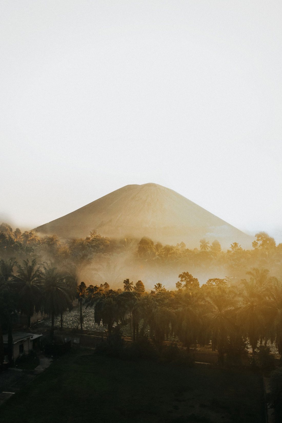
A smoking cone in a plain of grey sand, a Hindu temple at its foot and Java's highest volcano on the horizon: Bromo is the most famous sunrise in Indonesia. It is also a living volcano in a park hit hard by fire in 2026. Here is how the caldera works, which viewpoint to choose, how to get there and what is open right now.
Is Mount Bromo open right now?
Partly. As of 19 October 2026 the Bromo tourist area is open, but since 21:30 on 17 October the national park has stopped all visitors, jeep operators and residents at Lemah Pasar on the Pasuruan side, because a fire in the Penanjakan area is not yet under control. That means the classic Penanjakan 1 sunrise is off limits until the park lifts the restriction, and no end date has been set.
It has been a hard season. A wildfire that began on 3 August closed the whole park from 8 August; Bromo reopened on 20 August. Fire closed it again from 12 September, and it reopened on 19 September. On 15 October four members of a firefighting team, made up of park staff and local volunteers, died when strong winds trapped them in the Mentigen and Pusung Lingker areas on the Probolinggo side. Expect patrols, burned slopes and access changes at short notice, and check the park's announcements the day before you go.
The volcano itself was at Alert Level II (Waspada) on the four-level scale in August 2026, with people told to stay at least 1 kilometre from the active crater and warned that sudden steam-driven explosions can come without clear warning. Check the current level on MAGMA Indonesia before you travel.
What about the September 2026 hiking closures?
On 31 August Indonesia's forestry minister announced a temporary halt to hiking in nine national parks so that firefighting crews and helicopters could be focused on the fires; parks began applying it on 1 September. For Bromo Tengger Semeru, the closure targets the Mount Semeru climbing route. The park had already shut the Semeru trail to Ranu Kumbolo in late August, after a fire forced the evacuation of around 170 hikers from the lake. Bromo sightseeing is not a climb and stayed open under that order, closing only for its own fire emergencies. We could not find a confirmed reopening date for Semeru, and the park normally closes that trail every December to March anyway.
What exactly is Bromo, and what is the Sea of Sand?
Bromo is the youngest of a cluster of small cones that grew on the floor of the Tengger caldera, a volcanic basin 16 kilometres wide at the northern end of the massif that runs south to Semeru. It is not the highest point here, just the most active and the most visited. The plain around it is the Lautan Pasir, the Sea of Sand: fine grey volcanic ash and sand on the floor of the Sandsea caldera, roughly 9 by 10 kilometres.
The Smithsonian Global Volcanism Program dates the whole complex to about 820,000 years and counts five overlapping volcanoes, each cut by a caldera. Sandsea is the most recent, formed in stages in the late Pleistocene and early Holocene. Bromo typically puffs gas and steam, with occasional ash plumes and explosions: ash fell almost daily in April 2019, there were ash emissions in December 2020, and unrest picked up again in 2023.
Batok, the cone everyone mistakes for Bromo
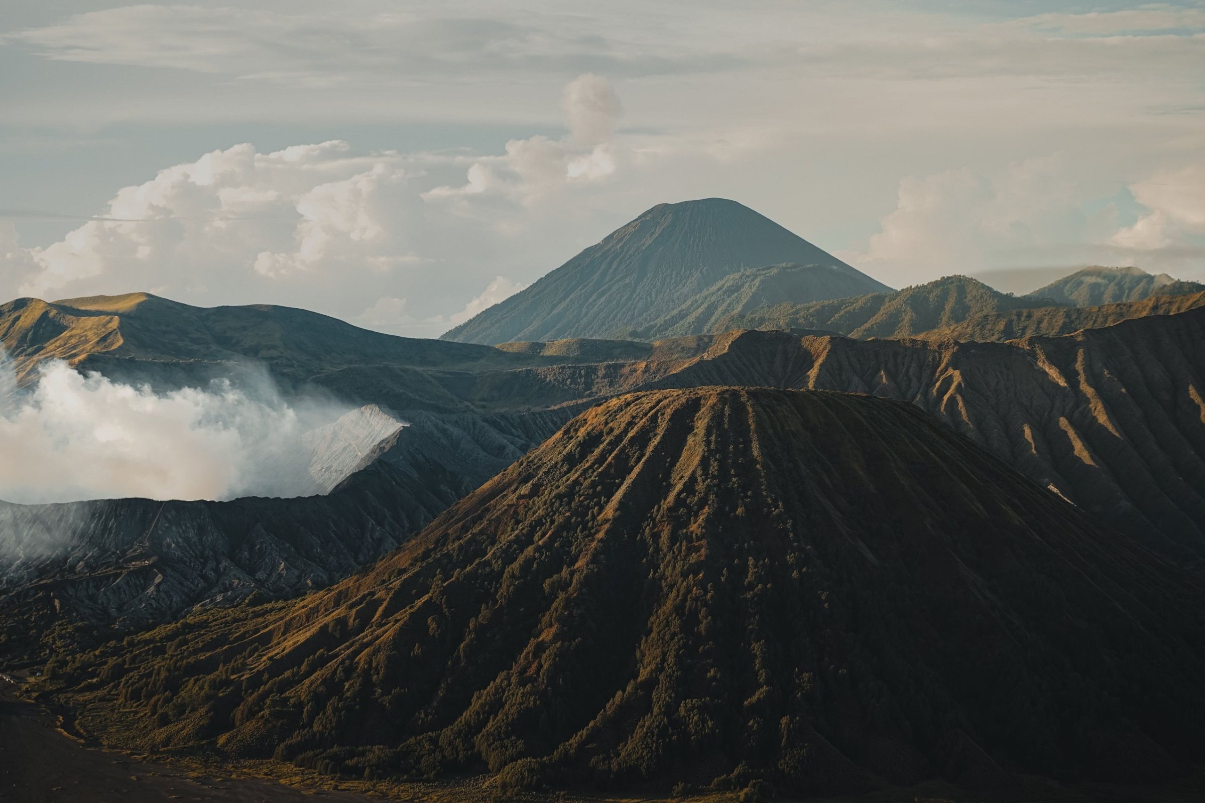
The perfectly ribbed, green-flanked cone standing beside Bromo is Batok, which shows none of Bromo's activity. If you are on the sand wondering which one to walk to, Bromo is the one with the smoke and the staircase.
Which is the best Bromo sunrise viewpoint?
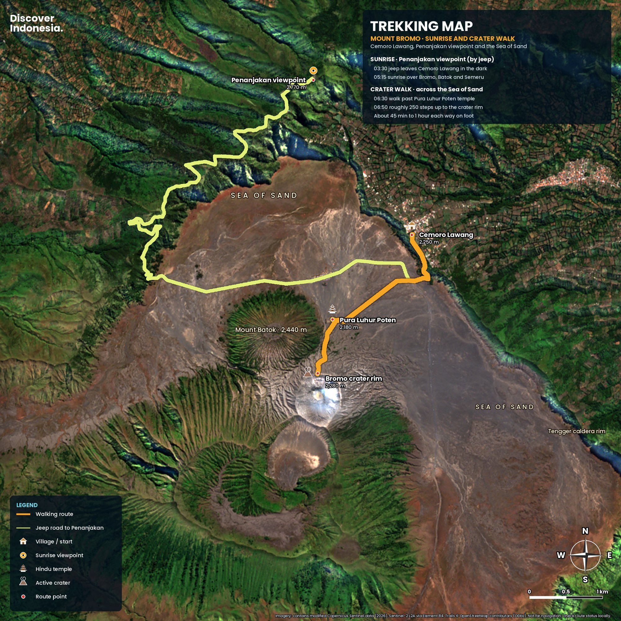
Penanjakan 1 has the definitive view, with Bromo, Batok and Semeru lined up below you, but it is the most crowded. Seruni Point (also called Penanjakan 2) is lower and closer, and the only major viewpoint easy to reach on foot from Cemoro Lawang. King Kong Hill and Bukit Cinta are calmer stops on the Penanjakan road. With Penanjakan closed since 17 October 2026, Seruni and the Cemoro Lawang side are where sunrise trips are running.
| Viewpoint | Where | Access | Crowds | Best for |
|---|---|---|---|---|
| Penanjakan 1 | Outer rim, Wonokitri (Pasuruan), about 2,770 m | Jeep, then a short walk; about 2 hours on foot from Cemoro Lawang | Very busy | The full panorama with Semeru |
| King Kong Hill | Below Penanjakan 1 on the same road | Jeep, then a dirt path | Busy but calmer | Tighter frame on Bromo and Batok, rock foreground |
| Bukit Cinta | Slopes of Penanjakan, near the jeep drop-off | Jeep, short walk | Moderate | Quieter dawn over the Sea of Sand |
| Seruni Point (Penanjakan 2) | Probolinggo side above Cemoro Lawang, about 2,400 m | Walk or jeep, then a long stepped path | Moderate | Close view into the caldera, no jeep needed |
| Mentigen Hill | Edge of Cemoro Lawang | Short walk from guesthouses | Low | Eye-level view, night-sky photography |
Penanjakan 1
The highest accessible point on the caldera rim and the reason most people come. Jeeps leave Cemoro Lawang around 3 a.m. and the platform fills well before first light, so arriving early matters more than anything else. The reward is mist pooling over the sand, Batok and Bromo in silhouette and Semeru smoking behind them; there are toilets and jacket rental at the top.
Seruni Point
Built as an overflow for Penanjakan, Seruni sits lower on the Probolinggo side and is reached by a long concrete staircase that locals call the Great Wall of Bromo. You lose a little height and Semeru can sit lower in the frame, but you gain a much closer look at the crater and a walk of 30 to 45 minutes uphill from Cemoro Lawang rather than a jeep queue. This is the best choice for independent travellers.
King Kong Hill and Bukit Cinta
Both are on the jeep road below Penanjakan 1, and drivers often stop at one when the summit is full. King Kong Hill, named after a rock formation on the cliff, frames Bromo and Batok more tightly; Bukit Cinta, Love Hill, is lower and usually quieter, with the light catching the textures of the sand first. Neither has quite the full panorama, but both beat a crowded railing.
Should I take a jeep tour or walk?
If you are staying in Cemoro Lawang, you can do the essential Bromo morning on foot: up to Seruni Point for sunrise, then down into the caldera and across the sand to the crater, roughly 45 minutes each way. A jeep is the practical way to reach Penanjakan 1 and King Kong Hill before dawn, and to add the savanna and the Whispering Sands in the south of the caldera.
A standard jeep morning runs: Penanjakan or a nearby viewpoint for sunrise, down to the jeep park on the Sea of Sand, a walk or horse ride to the crater stairs, then the Whispering Sands (Pasir Berbisik) and the savanna, often called Teletubbies Hill, which is green in the rainy season and gold in the dry. Jeeps take up to five people and are booked through guesthouses, village operators or tour companies. Agree what is included before you pay.
What is it like at the crater rim?
From the jeep park you walk across the sand and up a gully of ash to a concrete staircase of about 250 steps. At the top a narrow rim looks into a steaming, sulphur-smelling pit, and on a calm day you can hear the volcano roar. There are no barriers along most of the rim, so stay on the section by the stairs, keep well back from the edge and never step onto loose ground for a photo.
Horses wait at the jeep park to carry visitors as far as the foot of the stairs. If you use one, agree the price first and remember the riders are local Tenggerese families whose income depends on the caldera being open. When the alert level rises, the park can close the stairs and the 1 kilometre zone around the crater entirely.
Pura Luhur Poten
The walled temple on the Sea of Sand at the foot of Bromo is Pura Luhur Poten, the main temple of the Tengger people and the centre of the Kasada ceremony. It is built of dark volcanic stone rather than Bali's red brick, with its courts laid out in a mandala pattern. It is an active place of worship: view it from outside unless invited in, dress modestly and do not climb its walls for photos.
Who are the Tengger people, and what is Yadnya Kasada?
The Tengger, or Tenggerese, are a Javanese community living in highland villages around the caldera, such as Ngadisari, Wonokitri and Ngadas. They practise their own form of Javanese Hinduism, with Buddhist and older ancestral elements, speak an archaic Javanese dialect and regard Bromo as sacred. Yadnya Kasada is their great annual ceremony, when offerings are thrown into the crater.
Kasada falls on the 14th day of the month of Kasada in the Tengger calendar, at the climax of a month of observances. Offerings of rice, fruit, vegetables, flowers and livestock are carried to Pura Luhur Poten for prayers and then up to the crater rim before dawn, where they are cast in; some villagers climb down inside to catch them. The ritual recalls Roro Anteng and Joko Seger, a couple granted children on condition that the youngest be given to the volcano. Village priests (dukun) are also tested at the festival.
The park closes to tourists around Kasada: in 2026 the closure ran from 30 May to 2 June. It also closes for Nyepi and for several Tengger observances, including Wulan Kapitu days in January and December. If you hope to witness Kasada, check the date with the park and remember you are a guest at a religious ceremony.
How do I get to Mount Bromo?
Most travellers reach Bromo through Probolinggo on Java's north coast, then climb to Cemoro Lawang on the northern rim, the closest village to the crater. The other approaches are from Malang via Tumpang (south-west), from Pasuruan via Tosari and Wonokitri (west, nearest Penanjakan), and from Lumajang via Senduro (south-east). The park's official gates are at Cemoro Lawang (Probolinggo), Wonokitri (Pasuruan), Coban Trisula (Malang) and Senduro (Lumajang).
From Surabaya
Surabaya's Juanda airport is the main gateway. Trains from Surabaya to Probolinggo take two to three hours, as does a private car on the toll road. Buses run from Bungurasih (Purabaya) terminal but are less predictable.
From Probolinggo to Cemoro Lawang
Green public minibuses (bemos) leave from near Bayuangga bus terminal and take about 1.5 to 2 hours up the mountain, departing when full; you can also charter the whole vehicle. Ignore anyone who tells you there is no public transport. Ride-hailing cars will take you up but rarely come back, so arrange your return before your driver leaves.
From Malang and Tumpang
Malang, a cooler highland city with its own airport, suits a sunrise jeep trip that leaves around midnight via Tumpang and enters the caldera from the south, past Jemplang and across the savanna. It costs more and means a long night, but pairs well with waterfalls such as Tumpak Sewu.
From Bali
Take the ferry from Gilimanuk in west Bali to Ketapang near Banyuwangi in East Java, or fly to Surabaya. Coming overland, most people do Ijen first, since it is near Banyuwangi, then continue west to Bromo and fly home from Surabaya or Malang. Packaged Bromo and Ijen trips from Bali usually run three or four days.
Where should I stay for Bromo?
Stay in Cemoro Lawang if you want to walk: guesthouses sit right on the rim, you can reach Seruni and the crater on foot, and the 3 a.m. start is painless. It is basic and cold. Ngadisari and Sukapura, lower down the Probolinggo road, have more comfortable lodges and a slightly warmer night, at the cost of a drive. Tosari and Wonokitri on the Pasuruan side are closest to Penanjakan 1, while Malang trades proximity for city comfort and a midnight departure.
When is the best time to visit Bromo?
The dry season, roughly May to September or October, gives the best odds of a clear sunrise, with July and August usually clearest. From about November to April the rains bring cloud and fog that can hide the caldera completely, though the savanna turns green. Whatever the month, aim for the earliest viewpoint you can, because cloud tends to build through the morning.
Avoid Indonesian school holidays, long weekends, Christmas, Chinese New Year and the end of Ramadan if you can. The park caps visitors at a normal daily quota of 2,752, raised by 1,000 for peak holidays such as Lebaran 2026, and tickets must be booked online in advance through the official park website, bromotenggersemeru.id. Weekdays outside holidays are noticeably calmer, especially at Seruni and Bukit Cinta.
The dry season is also fire season. Recent large fires have come in the dry months, including a 2023 blaze of more than 500 hectares started by a flare at a wedding photo shoot, and the 2026 fires. If you travel then, build a spare day into your plan.
How cold is it at Bromo?
Cold enough to surprise people who flew in from Bali. Before sunrise on the rim, temperatures are often close to single digits Celsius, and in the dry months of May to September nights in the high caldera can drop below freezing. Bring a warm jacket, hat, gloves and a headlamp.
Common mistakes to avoid
- Not booking the entry ticket. Tickets are online and quota-limited; confirm whether your jeep price includes them.
- Assuming Penanjakan is open. In October 2026 it is not. Ask your operator which viewpoint they can actually reach that morning.
- Smoking or lighting anything. The park bans fires, flares and discarded cigarettes, and the 2023 and 2026 fires show why. Report any smoke to staff.
- Flying a drone without a permit. Drones need a permit from the park authority.
Can I combine Bromo with Ijen and Semeru?
Yes. Bromo and Ijen make the classic East Java volcano loop: Bromo for sunrise, then a long drive east towards Bondowoso or Banyuwangi for a night hike at Ijen, then on to Bali by ferry. Allow at least three days and two nights; four is more comfortable. Check Ijen's own status and rules separately before you go.
Semeru, at 3,676 metres Java's highest mountain, rises on the southern side of the same park. In 2026 the trail reopened on 24 April only as far as the lake at Ranu Kumbolo, from Ranu Pani, with a mandatory local guide and a quota of 200 hikers a day, with the summit off limits. It has been closed since late August because of fire. If you are planning a multi-day trek in Indonesia, our guide to climbing Mount Rinjani covers the trek most people choose instead.
Plan your trip
- Time needed: one night in Cemoro Lawang is the minimum; two nights gives you a weather backup.
- Book: park ticket online in advance; jeep through your guesthouse or a licensed local operator.
- Pack: warm layers, gloves, headlamp, dust mask or buff, closed shoes, sunscreen.
- Check: park announcements for fire closures, MAGMA Indonesia for the alert level, and Tengger ceremony dates.
For the geology, the eruption history and safety zones in detail, see our Mount Bromo volcano page. Our Discover Indonesia: Mount Bromo guide goes further into routes, viewpoints, where to stay and how to plan a Bromo and Ijen trip, and Discover Indonesia: Java puts it in the context of the whole island. All titles are on our guides page.
Facts checked October 2026. Access around Bromo has changed repeatedly during the 2026 fire season and the alert level can change at any time; check the Bromo Tengger Semeru National Park (BB TNBTS) announcements and MAGMA Indonesia before you travel.
- Tengger Caldera (Smithsonian Global Volcanism Program)
- TNBTS batasi akses wisata ke Penanjakan Bromo akibat kebakaran (Antara, 18 October 2026)
- Akses Wisata Bromo Kembali Dibatasi Imbas Kebakaran Lahan (CNN Indonesia)
- Report on the October 2026 Bromo wildfire deaths (Bernama)
- Gunung Bromo Kembali Dibuka 19 September 2026 (Jatim Times)
- Wisata Gunung Bromo Masih Ditutup, Kapan Dibuka Lagi? (detikJatim)
- TNBTS: Wisata Bromo Tetap Buka, Pendakian Semeru Ditutup Total (Metro TV)
- Indonesia Closes Hiking at 9 National Parks (Deep Arrival)
- Indonesia closes national park in East Java as wildfire expands (Al Jazeera)
- Bromo Tengger Semeru National Park reopens following wildfire closure (TTG Asia)
- Kebakaran Meluas, Aktivitas Gunung Bromo Level II Waspada (Okezone)
- Jalur pendakian Gunung Semeru dibuka pada 24 April 2026 (Antara Jatim)
- Libur Lebaran 2026, kuota wisata Gunung Bromo ditambah 1.000 orang per hari (Jawa Pos)
- Jadwal Penutupan Pendakian Semeru dan Bromo 2026 (IDN Times)
- Tenggerese people (Wikipedia)
- Mount Bromo Guide: Tips for Independent Travelers (Backindo)
- Mount Bromo Penanjakan Hill (Bromo Java Tour)