At 3,726 metres, Rinjani is Indonesia's second-highest volcano and one of the great treks of Southeast Asia: a night climb to the summit, a crater lake with hot springs, and a sunrise over Bali and Sumbawa. It is also a serious mountain, with stricter rules since 2025. These are the questions people ask most before they go, answered day by day and with the trail status as of October 2026.
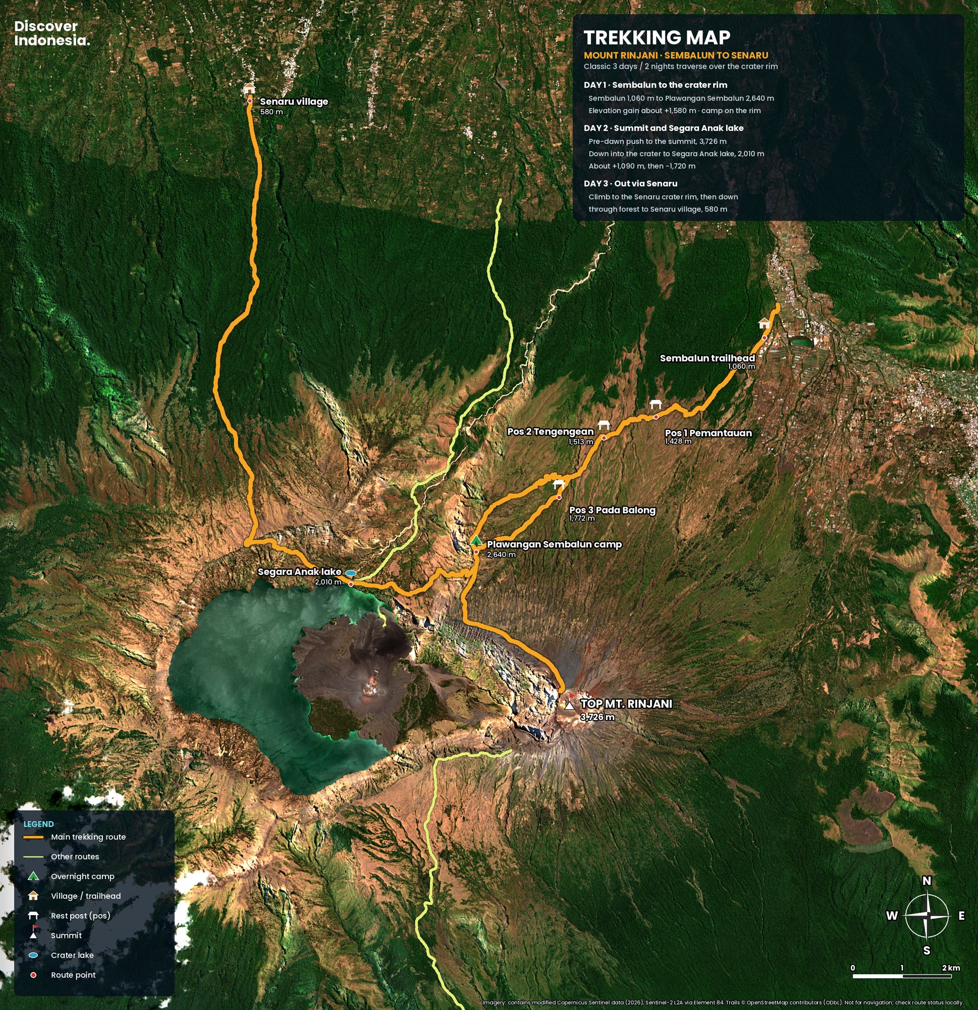
Is Mount Rinjani open right now?
Yes, mostly. As of mid-October 2026 the Sembalun, Senaru, Timbanuh, Tetebatu and Aik Berik routes are open, and booking through the park's eRinjani app resumed at 6 a.m. on 3 October 2026 after a pause during this year's fire season. The Torean route was closed after a forest fire in late September and was not on the park's list of operating routes when Senaru reopened. Check the eRinjani app and the park's announcements before you book.
The 2026 season has been stop-start. All routes were closed from 1 January to 31 March for the rains. On 1 September, with wildfire risk high, the park stayed open on a limited basis but suspended new eRinjani bookings. On 22 September a fire broke out at Bukit Setampol in the Torean area, eventually burning a provisional 1,100 hectares or so; Torean closed the next day and Senaru was shut too, reopening on 3 October. Indonesian reports differ on whether Torean reopened with it, so treat it as closed until the park confirms otherwise. Staff now check bags for anything that could start a fire.
How hard is the Rinjani trek?
Hard. The first day climbs well over 1,000 metres from Sembalun to the crater rim camp at roughly 2,640 metres. The summit push starts around 2 a.m. and gains about another 1,100 metres in three to four hours, much of it on loose volcanic scree. Then you descend more than 600 metres into the caldera to the lake, and climb back out the other side. You don't need climbing skills, but you do need good fitness, proper boots and the willingness to turn back.
Since August 2025 the national park has classed Rinjani as a grade 4 climb, not meant for novices. Under the new rules it may ask for proof of earlier mountain experience, such as photos or certificates from an easier peak. If Rinjani would be your first mountain, climb something smaller first; on Bali, Mount Agung or Batur are the usual warm-ups.
How should I train for Rinjani?
Train for long days on your feet rather than speed: stairs or hill walks with a loaded daypack two or three times a week for six to eight weeks, including some sessions of four hours or more. Downhill legs matter as much as uphill ones, and boots should be broken in before, not on, the mountain. Altitude is moderate but real: sleeping at about 2,640 metres and summiting at 3,726 can bring headaches, nausea and poor sleep. Drink plenty, and tell your guide early if a headache worsens. The cure is going down.
Sembalun or Senaru: which route should I take?
Most people go up from Sembalun and come down through Senaru. Sembalun, on the east side, starts higher and crosses open grassland with almost no shade, and it leads to the rim camp below the summit, which is why it is the route for summit climbers. Senaru, in the north, starts much lower at about 600 metres and climbs through tropical forest to a rim overlooking the lake. It has no direct summit approach, so it suits shorter treks or the way down.
Going up Sembalun and down Senaru means the big climb happens in the open on day one, with the summit straight above camp, and the long descent on day three is in shade. The reverse means climbing about 2,000 metres through forest just to reach the rim. The southern routes, Timbanuh, Tetebatu and Aik Berik, are quieter alternatives.
What happens on each day of the 3-day Rinjani trek?
On the classic three-day, two-night crossing you walk from Sembalun to the rim camp on day one, climb the summit at dawn and drop to the lake on day two, then climb to the Senaru rim and descend to Senaru village on day three. Expect six to eight hours of walking a day, and more on day two. The table gives the outline; the detail follows.
| Day | Route | Walking time |
|---|---|---|
| Day 1 | Sembalun, Pos 1, Pos 2, Pos 3, Plawangan Sembalun rim camp (~2,640 m) | 6–8 h |
| Day 2 | Summit (3,726 m) at dawn, back to camp, down to Segara Anak (~2,000 m) and the hot springs; some groups continue to the Senaru rim | 8–12 h |
| Day 3 | Lake or Senaru rim (~2,640 m) down through forest to Senaru (~600 m) | 5–8 h |
Day 1: Sembalun to the crater rim
After registration and the safety briefing at the Sembalun office, the trail crosses farmland and savanna, wide open and hot by mid-morning. Pos 1 sits at about 1,300 metres, Pos 2 at about 1,500 and Pos 3 at about 1,800; these are shelters where groups rest and porters cook lunch. Above Pos 3 the gentle walking ends. The last three hours are a relentless climb up a series of steep ridges to Plawangan Sembalun on the crater rim, at around 2,640 metres.
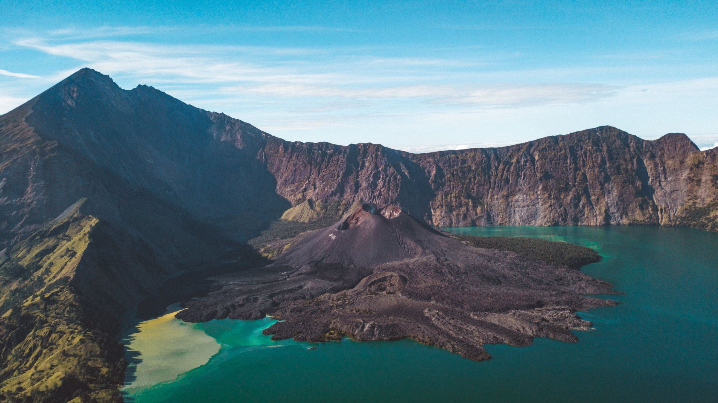
The rim camp is a long line of tents with the caldera, the lake and the young cone of Barujari below you, and Agung on Bali on the western horizon at sunset. It is cold after dark, and the alarm goes at around 1.30 a.m.
Day 2: summit, lake and hot springs
After the summit (see below), most groups are back at camp for breakfast by around 8 a.m., then descend more than 600 metres to Segara Anak in about three hours on steep, rocky ground. Lunch is by the lake.
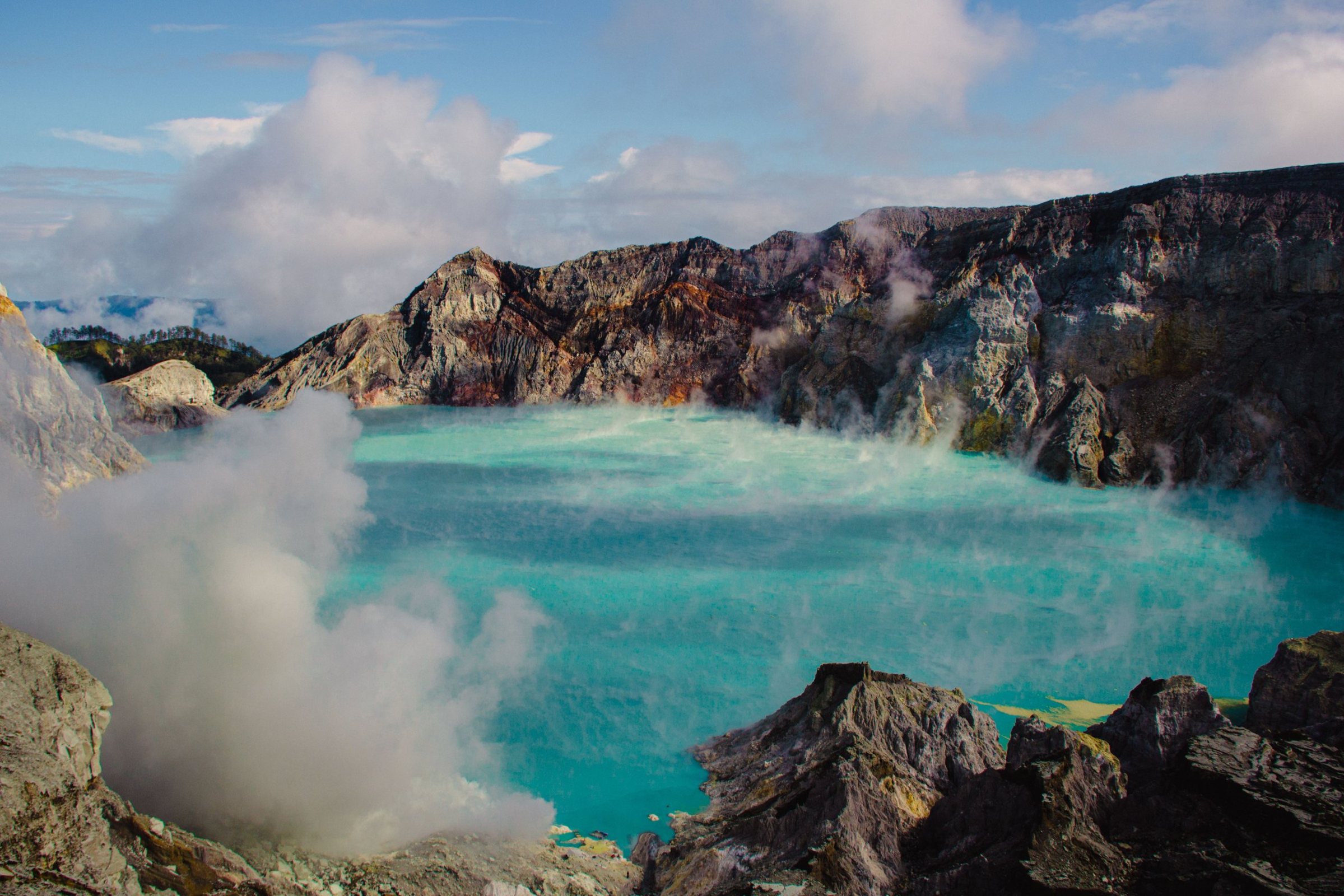
Segara Anak covers about 11 square kilometres and lies at around 2,000 metres. Its water is warm at the surface, around 20 to 22 °C, because hot springs feed it, and a short walk from the shore brings you to natural hot pools where trekkers soak their legs. Four-day trips sleep by the lake; on three-day trips many groups climb another three hours or so that afternoon to the Senaru rim, at about 2,640 metres, and camp there.
Day 3: Senaru rim to Senaru
The final day is almost all downhill: around 2,000 metres from the Senaru rim to the village at about 600 metres, in five to six hours. The upper part is open and rocky; lower down the trail enters tall tropical forest, muddy after rain. Trekking poles save your knees here. Most operators drive you on to Senggigi, the Gili harbour at Bangsal or the airport the same afternoon.
What is the summit push really like?
It is the hardest three to four hours of the trek and the reason most people come. You leave Plawangan Sembalun around 2 a.m. by headlamp, climb a firm ridge for the first hour, then reach the long final slope of loose scree where every two steps up slide one step back. The aim is the summit for sunrise, around 5.30 to 6 a.m., before clouds rise from the forest.
The upper ridge is narrow, exposed and windy, with long drops into the caldera on one side. Wear every layer you have, gloves included, because you move slowly and the wind cuts through. From the top, on a clear morning, you see the lake inside the caldera, Bali's Agung to the west and Sumbawa to the east. The descent is quick on scree, slower on the ridge, and treacherous for tired legs. Many accidents happen on the way down.
Turning back is normal, and some trekkers skip the summit altogether. A guide who talks about turning back is worth more than one who promises the summit.
How many days do I need?
Three days and two nights is the classic: rim camp on day one, summit and lake on day two, out through Senaru on day three. Four days adds a slower lake day with time in the hot springs. Two days is enough for the crater rim only, usually from Senaru or Sembalun, without the lake. Two-day summit trips exist but are punishing and leave no margin for bad weather.
How do I get to Sembalun or Senaru?
Fly into Lombok International Airport near Praya, about 40 minutes from Bali, then drive north: allow roughly three to five hours to Senaru or Sembalun depending on traffic and which trailhead. From Bali by sea, fast boats run from Padang Bai or Serangan to Bangsal on Lombok's north-west coast in about two and a half to three and a half hours, and Senaru is about two hours' drive from Bangsal. Most operators include transfers.
The public ferry from Padang Bai to Lembar takes four to six hours. If you are combining Rinjani with the Gili islands, the Bangsal route is the natural one.
Where should I stay before the trek?
Sleep the night before in Sembalun Lawang, a cool farming valley with homestays at the foot of the mountain, or in Senaru on the northern slope if you start there. Both have trekking organisers, and both beat a 3 a.m. drive from Kuta or Senggigi.
What are the Senaru waterfalls, and are they worth a day?
Yes. Sendang Gile and Tiu Kelep are two waterfalls below Senaru village, a good half-day walk for non-climbers or for loosening legs the day after. Sendang Gile is about 15 minutes from the village on a paved path, mostly steps. Tiu Kelep, the larger fall, is further on, along an irrigation channel and through the river two or three times.
Hire a local guide for Tiu Kelep: the path is unclear and the crossings are slippery.
When is the best time to climb Rinjani?
The trails are normally open from April to December. July and August are the driest and clearest months but also the busiest, and quotas can sell out. September is a good balance, nearly as clear with fewer people. April to June and October are quieter, while November and December bring more rain. Whenever you go, aim for the summit at sunrise: clouds usually build by mid-morning.
The dry months are also fire season: 2026 brought a booking pause and closures in September, so keep dates flexible. The park closes all routes every rainy season, usually from January to the end of March.
Do I need a guide and a permit?
Yes, both. Every trek must be booked through eRinjani, the national park's official online system; you can't pay at the gate. Foreign trekkers book through a licensed trekking operator, and certified guides and porters are mandatory. Daily numbers are capped, rules were tightened after accidents in 2025, and the entrance fee for foreign visitors rose on 3 November 2025. Fees and rules change often, so confirm the current ones with your operator.
What changed after the 2025 accidents?
In June 2025 a young Brazilian woman, Juliana Marins, fell from the summit trail and died before rescuers could reach her; falls involving Malaysian, Swiss and Dutch hikers followed in June and July. The Plawangan Sembalun to Segara Anak trail was closed from 18 July, all routes closed in August, and the park reopened under new standard operating procedures.
- Health and insurance: a health certificate is required, and from 1 October 2025 so is insurance cover; bring a policy that covers trekking above 3,000 metres and evacuation.
- Guides: certified guides only, with a cap on how many trekkers each guide may lead (around four or five under the 2025 rules), so someone can stay with a trekker who falls ill.
- Briefing and kit: a safety briefing before every trek, and operators must make sure you carry warm clothing, a sleeping bag and first aid.
- Rescue: a rescue post with ropes and emergency gear at Plawangan, and safety work on the most exposed sections of trail.
- Behaviour: no portable speakers, no single-use plastic, no fires.
How do I choose a Rinjani trekking operator?
Use an operator licensed with the park that books through eRinjani, and ask to see the guide's certification. Ask exactly what the price includes (park fees, insurance, transfers, tents, sleeping bags and their rating, food, water) and what happens if the route closes: a good operator reroutes or refunds. Ask about the porters too. The better operators give them proper shoes, warm clothes, shelter at camp and fair pay; unusually cheap trips usually save on exactly those things.
What are the rules on rubbish?
Rinjani is the pilot for Indonesia's zero-waste national park policy, announced in May 2025. Staff record what each group carries up, single-use plastic is banned, and everything must come back down. Groups that can't account for their gear face fines and a place on the climbing blacklist. The problem is real: in 2024 the park collected 12 tonnes of rubbish from the climbing routes, with the lake shore a notorious spot.
How cold does it get, and what should I pack?
Colder than you expect. Nights on the crater rim can drop to a few degrees above freezing, and the summit at dawn is windy and bitter. Bring warm layers, a hat and gloves, a rain jacket, gaiters, a swimsuit for the hot springs, a headlamp for the 2 a.m. start, trekking poles for the scree, sun protection for the exposed Sembalun slopes and around three litres of water a day. Porters usually carry the tents, sleeping bags and food, but check how warm the sleeping bag actually is.
For the geology, the 1257 eruption and the sacred side of the mountain, see our Mount Rinjani volcano page.
Is it safe to climb Rinjani?
It is safe with a licensed guide, the right gear and a willingness to turn back, but it is not a casual hike. The summit ridge is steep and exposed, fog can arrive without warning, and there have been fatal falls. After the July 2018 earthquake, landslides left more than 500 hikers and guides stranded on the mountain until they were evacuated. Inside the caldera, the young cone of Gunung Barujari erupted in 2009, 2015 and 2016, and the park closes when it is active. Check the alert level from Indonesia's volcano agency (MAGMA Indonesia) before you go.
Most trouble on Rinjani is ordinary: cold, exhaustion, a fall on scree, getting separated in cloud. Stay with your guide, especially on the summit ridge, and never rest alone off the trail. Indonesia's emergency number is 112.
Why is there a lake inside the volcano?
Because a mountain disappeared. Rinjani once had a neighbour, Samalas, thought to have stood around 4,200 metres high. In 1257 it erupted in one of the largest volcanic events of the past several thousand years, then collapsed into its own emptied magma chamber. The caldera it left, about 6 by 8.5 kilometres across, now holds Segara Anak, the "child of the sea", sacred to Lombok's Sasak and Hindu communities. Scientists only matched the eruption to Lombok in 2013, using traces in polar ice.
How do I plan a Rinjani trip?
Pick dates between April and October with a spare day either side, choose a licensed operator who books through eRinjani, buy insurance covering trekking above 3,000 metres, and get your health certificate as instructed. Check MAGMA Indonesia and the park's announcements the week before, sleep a night in Sembalun, and save a morning for the Senaru waterfalls.
Our Discover Indonesia guides to Rinjani and Lombok cover the routes, itineraries, where to stay and practical planning around the trek in more depth. Browse all of them on our guides page.
Facts checked October 2026. Trail status, quotas, fees, guide ratios and rules change often, and fire-season closures can come at short notice; always confirm with Mount Rinjani National Park (Balai TNGR), the eRinjani app and your operator before you travel.
- Rinjani (Smithsonian Global Volcanism Program)
- Jalur Pendakian Senaru Gunung Rinjani Kembali Dibuka Pascakebakaran Hutan (NTBSatu, 3 October 2026)
- Lima Jalur Pendakian Gunung Rinjani Kembali Dibuka (Katadata, 3 October 2026)
- 589 Hektare Lahan Gunung Rinjani Terbakar, Jalur Pendakian Torean Ditutup (Katadata, 25 September 2026)
- Indonesia allows limited tourism at Mt Rinjani amid wildfire risk (The Star / Bernama, September 2026)
- Pendaki Gunung Rinjani Wajib Tahu, Ada Pengumuman Penting (JPNN, December 2025)
- Indonesia shuts Mount Rinjani routes to review climber safety protocols (TTG Asia, July 2025)
- Mount Rinjani reopens with stricter safety rules for climbers (TTG Asia, September 2025)
- New SOP for climbing Mount Rinjani (VOI, August 2025)
- Kenaikan Tarif Rinjani Berlaku 3 November 2025 (Merdeka)
- Gunung Rinjani jadi percontohan taman nasional nol sampah (Antara, May 2025)
- Sampah jadi tantangan misi pendakian kelas dunia Gunung Rinjani (Mongabay Indonesia, September 2024)
- Death of Juliana Marins (Wikipedia)
- Senaru waterfalls (Travelfish)