Mahameru, the Great Mountain, is the highest point on Java and one of the most active volcanoes in Indonesia. For years hikers have only been allowed as far as Ranu Kumbolo, a cold mountain lake on its northern flank, and since a forest fire in late August 2026 even that trail has been closed. Here is the route, the rules and what has happened this year.
Is Mount Semeru open for hiking right now?
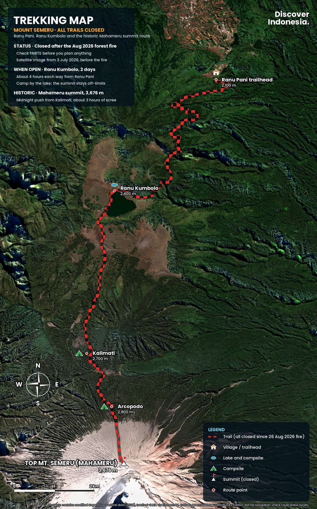
No. As of mid-October 2026 all hiking on Semeru is closed. Bromo Tengger Semeru National Park (TNBTS) shut every trail on 26 August 2026 after a forest fire broke out near the route to Ranu Kumbolo, and on 31 August the Ministry of Forestry added the Semeru climbing route to a list of nine national parks closed to hiking because of fire risk. We could find no reopening announcement, so check the park's official channels before you plan anything.
Even in a normal year the trail has fixed closures. The park's 2026 calendar closes Semeru from 1 January to 31 March and again for the whole of December, for ecosystem recovery and bad weather. It also closes for Tengger ceremonies in Ranu Pani village: in 2026 the trail was shut from 7 to 18 August for that reason, only a week before the fire.
The summit itself is a separate question. Mahameru has been off-limits for years because the volcano erupts almost every day. When the trail does open, hikers may go only as far as Ranu Kumbolo and back.
What happened in the August 2026 fire?
On 26 August 2026 a fire started in the Ranu Kembang block of the park, close to the hiking trail between Ranu Pani and Ranu Kumbolo. About 170 hikers were camped at Ranu Kumbolo, the only designated campsite on the mountain. The park closed the trail the same day, and the next afternoon all of them walked down to Ranu Pani with their registered guides and park staff, unhurt.
The fire was part of a bad season across East Java. A fire inside the Bromo caldera from 3 August had already closed Bromo tourism from 8 to 20 August. By late August the park reported around 170 hectares burned on Semeru, mostly savanna, and on 4 September Indonesia's disaster agency, BNPB, counted fires on Semeru, Wilis, Arjuno-Welirang and other East Java mountains, with access to Kawah Ijen also closed.
The park said Semeru would reopen only once all hotspots were confirmed out and a joint team judged the trail safe. During the closure, the road between Malang and Lumajang through Poncokusumo and Senduro stayed open, and the lakeside campsite at Ranu Regulo next to Ranu Pani village stayed open to visitors.
Why is the Mahameru summit closed?
Because Semeru is in near-constant eruption, as it has been since 1967, and its worst events in recent years have been large and sudden. The national volcano agency has kept the mountain at Alert Level 3 (on a scale of 1 to 4) since 29 November 2025, with a 5 km exclusion zone around the summit crater, Jonggring Saloko. No hiker is allowed beyond Ranu Kumbolo.
The history explains the caution. On 4 December 2021, heavy rain helped collapse the summit lava dome and sent pyroclastic flows and later mudflows down the southeast flank. More than 60 people died, villages in Lumajang regency were buried in ash and the Gladak Perak bridge collapsed. On 4 December 2022 another pyroclastic flow travelled about 12 km.
Then on 19 November 2025 a series of pyroclastic flows ran as far as 13 km down the southern and southeastern flanks. The alert was raised to Level 4, the highest, and more than a thousand residents went to shelters. That afternoon around 178 hikers, porters and guides were on the mountain and spent an anxious night at Ranu Kumbolo, about 8 km north of the crater and away from the flows, before walking out safely. The park closed the trail that day and only reopened it, to Ranu Kumbolo alone, on 24 April 2026.
The eruptions continue. Through mid-2026 the volcano produced daily explosions with ash plumes typically several hundred metres to about 2 km above the summit, and some pyroclastic flows ran about 4.5 km down the Kobokan valley. In the week of 8 to 14 October 2026 ash still rose 300 to 1,000 m above the crater on most days.
What is the Ranu Pani to Ranu Kumbolo trail like?
It is a moderate walk of roughly 2.5 to 4 hours one way, on a well-trodden path that climbs gently from Ranu Pani village at about 2,100 m to the lake at about 2,400 m. It passes four numbered rest posts and is far easier than the summit route ever was. The hard part is not the gradient but the cold at the lake and the early starts.
The route on the map continues past Ranu Kumbolo to Kalimati, Arcopodo and the summit. That section is the historic route and is closed. It is described below so you can read the map and understand the mountain, not as a plan.
| Stop | Approx. altitude | What it is | Status |
|---|---|---|---|
| Ranu Pani | 2,100 m | Tengger village, registration post and trailhead | Trailhead |
| Watu Rejeng | 2,350 m | Stretch of steep cliffs above a valley | On the permitted trail |
| Ranu Kumbolo | 2,400 m | Lake and the only designated campsite | Turnaround point |
| Tanjakan Cinta | Above the lake | Steep slope behind Ranu Kumbolo | Closed beyond the lake |
| Oro-oro Ombo | Above the lake | Wide savanna basin | Closed |
| Cemoro Kandang, Jambangan | Higher | Pine forest, then views of the summit cone | Closed |
| Kalimati | Higher | Former summit base camp | Closed |
| Arcopodo, Kelik, Mahameru | Up to 3,676 m | Forest ridge, tree line, sand and scree to the crater | Closed |
Ranu Pani to Watu Rejeng
The trail leaves the village past the registration office and fields of vegetables on the steep Tengger hillsides. Allow about an hour to Pos 1 on a stone path, then about 45 minutes more on gentler dirt trail to Pos 2. Beyond it the path runs along Watu Rejeng, where rock walls rise on one side and the ground falls away into a valley on the other. Local lore is full of mystical stories about this stretch, and it is a good place to watch your footing, not your phone.
Ranu Kumbolo
Pos 3 is a common rest stop with views over the clouds, and from Pos 4 the lake comes into sight below. Ranu Kumbolo covers somewhere between 12 and 15 hectares, depending on the source and the season, and sits in a grassy bowl ringed by hills. Hikers camp on its shore, and the classic photograph is sunrise over the gap in the eastern ridge with mist on the water. Clear dry-season nights can fall below freezing, with reports of around minus 4 °C, so a good sleeping bag matters more than anything else you pack.
Tanjakan Cinta and Oro-oro Ombo
Behind the lake rises Tanjakan Cinta, the "slope of love". The story goes that if you climb it thinking of someone and look back when called, that person is not the one for you. Over the top lies Oro-oro Ombo, a savanna of around 20 hectares that turns purple with verbena flowers around April. The verbena is an invasive plant, and the park asks hikers not to carry flowers or seeds down the mountain. Neither spot is part of the permitted hike at the moment.
Cemoro Kandang to Kalimati
Before the closures, the route continued through the pines of Cemoro Kandang to Jambangan, the first place with a full view of the smoking summit cone, then dropped gently to Kalimati, a broad open field that served as the last main camp. Water came from Sumber Mani, a spring about 30 minutes' walk away. Even in the years when the summit was open, park insurance for hikers covered the route only as far as Kalimati.
Arcopodo, Kelik and the summit
Above Kalimati the old route climbed a steep forested ridge past Arcopodo to Kelik, the last vegetation, then onto a slope of loose sand and gravel as steep as 60 degrees. Summit attempts started around 1 a.m. and took six to seven hours from Kalimati. Falling rocks, toxic gas near the crater and sudden weather all killed people here. The park's own records listed 28 deaths and 3 missing climbers on Semeru between 1969 and 2009, and more since.
How do I book the Semeru trek when it reopens?
Online only, through the national park's booking site, bromotenggersemeru.id. Under the rules that applied from 24 April 2026, tickets went on sale between 30 and 2 days before the hike, the quota was 200 hikers a day, trips were limited to two days and one night, and every group had to hire a local guide. Expect the rules to be reviewed before any reopening.
The other 2026 requirements were:
- Group size: two to ten people.
- Documents: original ID (a passport for foreigners) and a health certificate (surat keterangan sehat), checked at re-registration in Ranu Pani. Small clinics around Tumpang market issue health certificates for hikers.
- Briefing: every hiker attends the safety briefing at Ranu Pani before setting off.
- Route: only the official Ranu Pani trail. Other approaches to the summit are illegal, and in June 2026 a hiker on an unofficial route from Ampelgading fell about 375 m into a ravine and was lucky to survive.
- Waste: everything you carry up comes back down. Rubbish was a long-standing problem on Semeru, with the park once reporting around 1.5 tonnes a month.
If the park closes the trail after you have booked, the usual practice in 2025 and 2026 has been to offer a refund or a new date through the booking system.
How do I get to Ranu Pani?
The usual approach is from Malang. Hikers gather at Tumpang market on the eastern edge of Malang, where jeeps can be chartered and gear can be rented or bought, then drive about two to three hours up to Ranu Pani on a now-paved mountain road. The drive skirts the Bromo massif and passes the green hills the locals call Bukit Teletubbies.
Malang itself is easy to reach by train from Surabaya, Yogyakarta and Jakarta, and Surabaya's Juanda airport is the main international gateway to East Java. The alternative approach comes from the east, via Lumajang and Senduro. Ranu Pani has simple homestays, and many hikers sleep there the night before to start early and get used to the altitude.
Because the road from Tumpang crosses the edge of the Tengger caldera, Semeru combines naturally with a sunrise at Bromo. Our guide to watching the sunrise at Mount Bromo covers the viewpoints and timings on that side of the park.
When is the best time to hike to Ranu Kumbolo?
The dry season, roughly May to October, gives the clearest mornings, but it is also the fire season, as 2026 showed. On the park's calendar the trail can only be open from April to November, and it often closes at short notice for eruptions, fire or ceremonies. April and May bring greener hills and the verbena on Oro-oro Ombo, with more chance of rain.
Weekends and Indonesian school holidays fill the 200 daily places fastest. A midweek date in the shoulder months is the easiest to book and the quietest at the lake. Whenever you go, pack for winter: warm layers, hat, gloves, a sleeping mat and bag rated below freezing, a headlamp and a rain shell.
Why is Semeru called Mahameru, and why is it sacred?
Mahameru means "the Great Mountain" in Sanskrit, and Semeru takes its name from Meru, the mountain at the centre of the universe in Hindu and Buddhist cosmology. A 15th-century East Javanese text, the Tantu Panggelaran, tells how the gods carried Mount Meru from India to Java to weigh the island down and stop it from drifting, and how the peak was left as Mahameru. Indonesian Hindus regard the mountain as the abode of Shiva.
For the Tengger people who farm the slopes around Bromo and Ranu Pani, Semeru remains a holy mountain, and the national park closes the trail for their ceremonies. Visitors in Ranu Pani are guests in a working Tengger village: dress modestly, ask before photographing people and offerings, and keep noise down at night.
Who was Soe Hok Gie?
Soe Hok Gie was an Indonesian student activist and writer who died near the summit of Semeru in December 1969, a day before his 27th birthday. He and his fellow climber Idhan Lubis, of the University of Indonesia's nature club Mapala UI, were overcome by toxic volcanic gas near the crater. They are remembered as the first climbers known to have died on Semeru.
Gie had argued that young people climb mountains to build healthy bodies and minds, and that love of one's country grows from knowing it up close. His diaries became a best-selling book and his life was made into a film, which turned Semeru into a pilgrimage for a generation of Indonesian hikers. A memorial plaque for the two men stood on the mountain for decades before it was removed in 2012.
Is it safe to hike Semeru?
The permitted trail to Ranu Kumbolo is safe for a fit walker with a guide when the park has opened it. The dangers on Semeru come from the volcano, fire and cold, and from people who ignore the rules. Ranu Kumbolo lies outside the main danger zone on the northern side, which is why hikers there were unharmed in November 2025, but ash can still drift over the camp.
The commonest mistakes are trying to sneak past the lake toward Kalimati, taking unofficial routes, underestimating night cold and lighting fires. The park asks visitors not to light campfires, flares or fireworks, and a flare set off during a pre-wedding photo shoot is blamed for a 2023 fire that burned more than 270 hectares around Bromo. Check the alert level on MAGMA Indonesia before you travel, and treat any closure notice as final.
Plan your Semeru trip
- Watch for the reopening: follow the TNBTS booking site and official social media; nothing is bookable until they announce it.
- Base: a night in Malang, then a night in Ranu Pani before the hike if you can.
- Time needed: two days and one night on the mountain, plus a day each side for travel. Add a day for Bromo.
- Bring: passport, health certificate, warm sleeping gear, layers, headlamp, water bottle and a bag for your rubbish.
- Alternatives if it is closed: Ranu Regulo by Ranu Pani village, the Bromo caldera when open, and our Mount Semeru volcano page for the geology and eruption history. For other East Java and Lombok volcanoes see Bromo, Ijen and our Rinjani trekking guide.
Our Discover Indonesia guides to Mount Semeru, Mount Bromo and Java cover the wider region in more depth, with routes, itineraries, where to stay and practical planning. Browse them all on our guides page.
Facts checked October 2026. Semeru's trail status, alert level, quotas and rules change at short notice; confirm with Bromo Tengger Semeru National Park (bromotenggersemeru.id) and MAGMA Indonesia before you travel.
- Semeru: eruptive history and weekly reports (Smithsonian Global Volcanism Program)
- Mount Semeru trails closed after forest fires, 170 climbers evacuated (Antara)
- Pendakian Gunung Semeru ditutup total (detikJatim)
- TNBTS: Wisata Bromo tetap buka, pendakian Semeru ditutup total (Metro TV)
- Sembilan taman nasional rawan karhutla ditutup sementara (IDX Channel)
- BNPB: Empat gunung di Jawa Timur hingga Kawah Ijen terbakar (Katadata)
- Indonesia to reopen Mount Semeru climbing routes on April 24 (Antara)
- Pendakian Gunung Semeru dibuka kembali, cuma sampai Ranu Kumbolo (IDN Times)
- Jadwal penutupan pendakian Semeru dan Bromo 2026 (IDN Times)
- Rute pendakian Gunung Semeru lewat Pasar Tumpang dan Ranu Pani (detikJatim)
- Climbers at Indonesia's Mount Semeru safe after sudden volcanic eruption (Al Jazeera)
- BB TNBTS perketat pengawasan di Semeru antisipasi pendaki ilegal (Antara)
- Gunung Semeru yang memeluk jenazah Soe Hok Gie (Liputan6)
- Bromo wildfire closes park (TTG Asia)
- Jangan ceroboh di Semeru (Tirto)