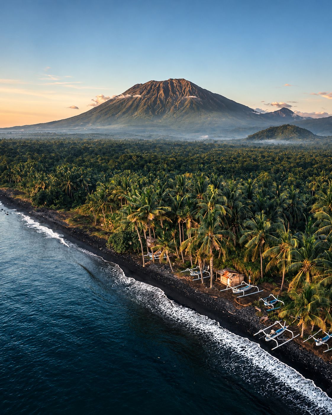
Gunung Agung is Bali's highest mountain and its holiest: the seat of the gods above Pura Besakih, and a volcano that killed more than a thousand people in 1963 and erupted again from 2017 to 2019. You can climb it, but only with a local guide, only when the temples allow it, and only if you are ready for a long, steep night on loose rock. Here is how the two routes compare, when to go and how to do it respectfully.
Can you climb Mount Agung right now?
Usually yes, with a licensed local guide, but check two things before you book: the volcano's alert level and the temple calendar. Indonesia's volcano agency (PVMBG) reported Agung at Level I, Normal, in mid-August 2026, its lowest level. The mountain is closed to climbers during major ceremonies at Pura Besakih and Pura Pasar Agung, and in extreme weather.
In 2026 there have already been two ceremony closures: four weeks from 28 March to 24 April for the great rites at Pura Agung Besakih, and a shorter one from 26 June to 2 July for the Aci Purnama Kasa ceremony at Pura Pengubengan, the temple above Besakih where the summit route begins. Closures are announced by the temple communities, often only days or weeks ahead, and passed to the guides. A good guide will know before you do, which is one more reason to book through one.
How high is Mount Agung?
About 3,000 metres. The Smithsonian Global Volcanism Program lists 2,997 m, other modern surveys give 3,031 m, and older maps and many Indonesian sources still quote 3,142 m. Whatever the exact figure, it is the highest point on Bali, and on a clear morning nothing on the island comes close.
The summit area runs about 1.5 kilometres from east to west. The true summit is on the western side; to the east lies a steep-walled crater roughly 800 metres across, partly filled with lava since the 2017 to 2019 eruptions. This shape matters for climbers: the shorter southern route reaches the crater rim, while only the long route from Besakih goes to the true top.
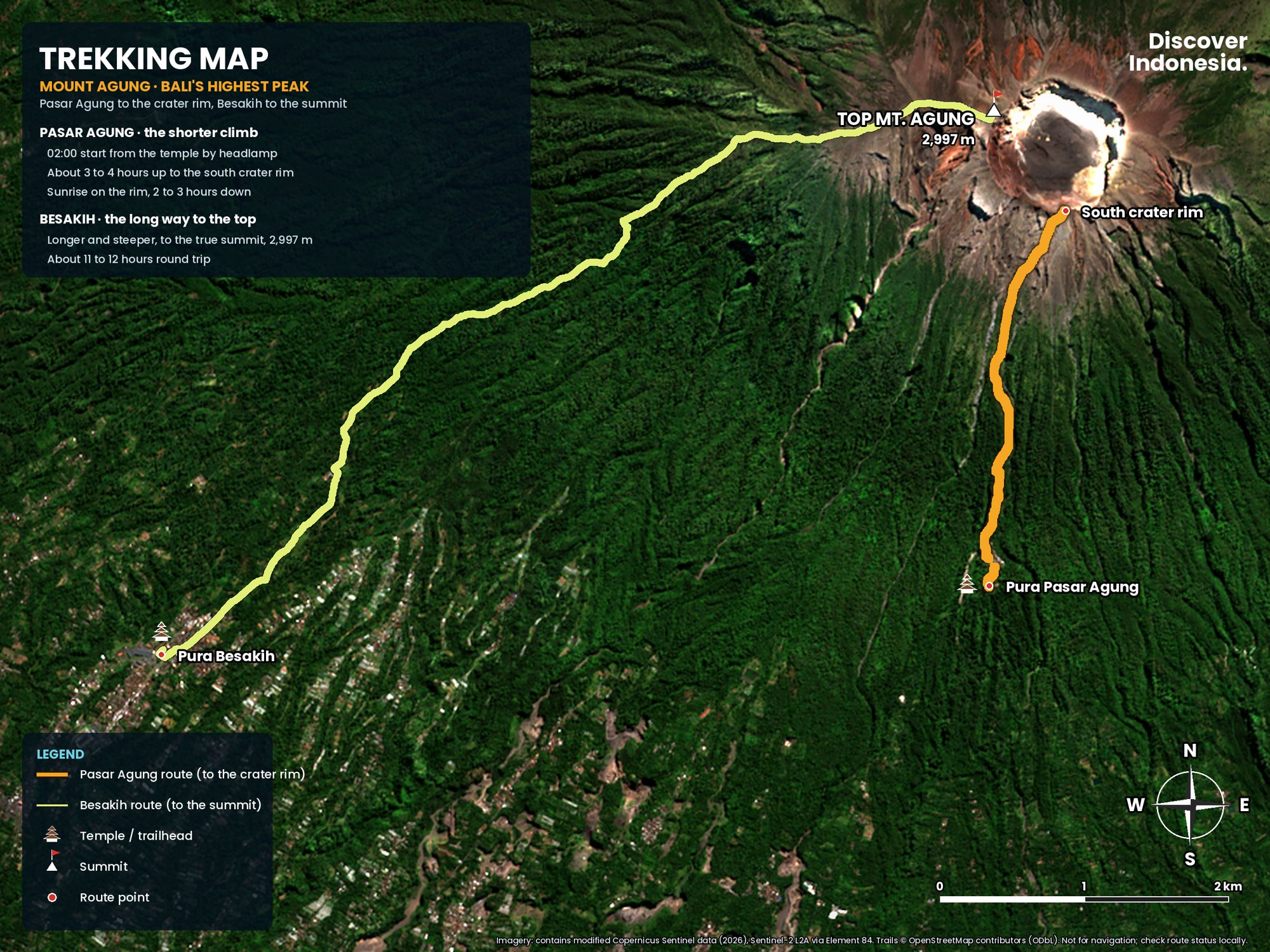
Pasar Agung or Besakih: which route should you take?
Most people climb from Pura Pasar Agung, which starts higher, takes about three to four hours up and ends on the south crater rim at roughly 2,866 m. Choose Besakih if you want the true summit and can handle a much longer day: six to seven hours up and five to six down. Both start in the middle of the night so you reach the top for sunrise.
| Pasar Agung route | Besakih route | |
|---|---|---|
| Start | Pura Pasar Agung, about 1,600 m, near Selat | Above Pura Besakih near Pura Pengubengan, about 1,150 to 1,200 m |
| Goal | South crater rim, about 2,866 m | True summit, about 3,000 m |
| Height gain | About 1,300 m | About 1,800 to 1,900 m |
| Time up | 3 to 4 hours | 6 to 7 hours |
| Time down | 2 to 4 hours | 5 to 6 hours |
| Typical start | Around 2 a.m. | Around midnight |
| View into crater | Yes, from the rim | Yes, from the summit ridge |
The Pasar Agung route
From the car park, 297 steps lead up to Pura Pasar Agung, a temple that sits on the southern flank at about 1,600 metres. Guides wait here, and the trail starts behind the temple. The first hour or so climbs steeply through forest on a rooted path with almost no switchbacks. Above the tree line the trail turns into open volcanic rock, slabs and loose gravel, and the last third to the rim is slow, steep and often on all fours.
At about 2,425 m a faint path splits off towards the true summit. That traverse is exposed, involves real scrambling and is poorly marked, so it is only for confident scramblers with a guide who knows it. Most groups stay on the main route to the rim, watch sunrise there and look down into the crater before descending.
The Besakih route
The Besakih route begins above the main temple complex, at the last temples on the hill around Pura Pengubengan, and climbs the southwest ridge all the way to the summit. The first hours are in dense forest, where the trail is steep, muddy after rain and tangled with roots. Above about 2,200 m the trees thin out, the path becomes stony and loose, and the final stretch follows a narrow ridge with steep drops on either side.
This is the more serious climb. There is an exposed section of a few hundred metres where a slip would have consequences, and strong winds on the ridge can make it dangerous to continue. The reward is the only full 360-degree view on the mountain. Plan on 11 to 12 hours in total, and on being very tired the next day.
How hard is it to climb Mount Agung?
Very hard for a one-night hike. It is far steeper and longer than the popular Mount Batur sunrise trek, with relentless climbing, loose scree and scrambling near the top. You need no technical climbing skills, but you do need solid fitness, good balance and a willingness to turn back.
What catches people out is the descent. Loose gravel and ash over hard rock make the upper slopes slippery, and after a sleepless night your legs are tired just as the ground gets most treacherous. Trekking poles help a great deal.
Accidents do happen. In January 2025 Bali's search and rescue agency recovered the body of a Korean climber on Agung, and the provincial government then barred climbing during extreme weather. Fatalities have mostly involved bad weather, unfit or unguided hikers. Do not climb in rain or high wind, and do not hike off the trail at the rim.
Do you need a guide to climb Mount Agung?
Yes. A licensed local guide is mandatory. In January 2025 Bali's Forestry and Environment Service issued a circular requiring climbers to use local guides who know the trails and conditions, and to follow instructions from staff at the climbing posts. A Norwegian tourist who climbed alone the following month, ignoring warning signs at the entrance, was caught and deported.
Guides are based in the villages around the trailheads, around Selat for Pasar Agung and in Besakih for the summit route, and most trekking operators in Bali work with them. They also find the way at night where paths fork, judge the weather and know when the mountain is closed.
What about the 2023 climbing ban?
In May 2023 Bali's governor, Wayan Koster, announced a ban on tourist activity on 22 of the island's mountains, after cases of foreigners behaving disrespectfully on sacred peaks. Guides and local leaders objected, and in practice guided climbs of Agung have continued. Since then the authorities have focused on mandatory guides, weather closures and ceremony closures.
When is Mount Agung closed for ceremonies?
Every year for the Ida Bhatara Turun Kabeh ceremony at Pura Besakih, held for 21 days from the full moon of the tenth Balinese month, which falls in March or April. The mountain usually closes for about four weeks around it: 6 April to 3 May in 2025 and 28 March to 24 April in 2026. Other temple ceremonies bring further closures with less warning.
These are not tourist rules dressed up as religion. For Balinese Hindus, Agung is the dwelling place of the gods and a replica of Mount Meru, the axis of the universe, and the temples on its slopes are where they are honoured. During major ceremonies the whole landscape is treated as sacred and climbing is suspended. In October and November 2024, for example, the mountain was closed for rites at Pura Pasar Agung itself, and guides cancelled bookings for two months.
If your Bali dates are fixed, build in a fallback. Mount Batur stayed open during the 2026 Agung closure, and the sunrise view of Agung from Batur is one of the best on the island.
What happened in the 1963 and 2017 eruptions?
In 1963 Agung woke after more than a century of quiet in what the Smithsonian calls Indonesia's largest and most destructive eruption of the 20th century. Between 1,100 and 1,900 people died. From 2017 to 2019 it erupted again, forcing more than 100,000 people to evacuate at times and closing Bali's airport.
1963 to 1964
Explosions began on 18 February 1963 and lava soon flowed down the northern slope. On 17 March a violent eruption sent pyroclastic flows down the flanks, and a second explosive phase on 16 May produced even more. Heavy rain then turned loose ash into lahars, rivers of mud and boulders that buried villages. The eruption, rated VEI 5, continued in bursts until January 1964. Lava flows passed Pura Besakih by only metres, and many Balinese saw the temple's survival as a sign from the gods.
2017 to 2019
Earthquakes beneath the mountain rose sharply in August 2017, and in September PVMBG raised the alert to Level IV, its highest. The first ash came on 21 November 2017. Within days lava was pouring into the crater, the exclusion zone was widened to 10 kilometres, and ash forced Ngurah Rai International Airport to close in late November, cancelling hundreds of flights and stranding thousands of travellers. By the end of the year lava filled about a third of the crater.
Explosions and ash plumes continued through 2018 and into 2019; the Smithsonian records the last eruption of that episode on 13 June 2019. The mountain stayed closed to climbers for long periods. The alert was lowered to Level II in July 2020 and to Level I in September 2021. A few weak plumes were reported in 2022, some of them unconfirmed. For the full volcanic story, see our Mount Agung volcano page.
What is the current alert level of Mount Agung?
The latest report we could confirm, from mid-August 2026, had Agung at Level I, Normal. Even at this level PVMBG asks visitors to limit activity around the crater, to avoid it in cloudy or rainy weather, and never to camp near the crater or descend into it. Check the live level on MAGMA Indonesia before you climb, since it can change within days.
When is the best time to climb Mount Agung?
The dry season, roughly April or May to October, gives the best chance of a clear sunrise and safe footing. August is usually the driest month. Avoid the rainy season from about November to March: wet rock and ash are treacherous and cloud often hides the view.
The dry season has its own catch: wind. From June to September strong gusts can sweep the upper ridge, and guides sometimes turn back before the top. Remember too that the dry season does not protect you from closures. The Turun Kabeh ceremony usually falls in late March or April, right at the start of the good weather, so May, September and early October are often the sweet spot.
What do you see from the top?
At first light you look east across the Lombok Strait to Mount Rinjani on Lombok, often standing clear above a sea of cloud. To the northwest lie the Batur caldera and its lake, with Mount Abang and the peaks of central Bali beyond. To the south you can see Nusa Penida, Nusa Lembongan and the lights of the southern coast fading into morning. If Rinjani tempts you next, our guide to climbing Mount Rinjani covers the routes and permits.
The views fade fast. Within an hour of sunrise cloud often covers the lower slopes, so take your photos early. On the Pasar Agung route the crater itself is the other highlight: a deep bowl with the dark new lava of 2017 to 2019 on its floor.
How do you get to the trailheads from south Bali?
Allow about two hours by car from Canggu, Seminyak, Kuta or Sanur, and about an hour and a half from Ubud. Both trailheads are in Karangasem regency in east Bali. For a 2 a.m. start at Pasar Agung, hotel pickups in the south are usually around 11 p.m.
Pura Pasar Agung is reached on a steep mountain road above Selat, in the village of Sebudi. The Besakih route starts from the Besakih temple area in Rendang district, also reached via Rendang. There is no useful public transport at night, so you need a driver, an operator's transfer or your own scooter, and a scooter on these steep, dark roads at midnight is not a good idea.
Where to stay
The better plan is to sleep close to the mountain. Sidemen, a valley of rice terraces south of Agung, is the most convenient base for Pasar Agung. Besakih itself has simple homestays a few minutes from the trailhead, ideal for the summit route. Amed, Candidasa and Kintamani are also within reach and give you an easier night before and a soft landing after.
What should you bring?
- Warm layers. You will sweat in the forest and then freeze on the rim before dawn. Bring a fleece or down jacket, a windproof shell, a hat and gloves.
- Proper hiking shoes. Good grip matters more than anything on scree and ash. Running shoes struggle on the descent.
- A strong headlamp with spare batteries. Guides sometimes provide basic ones, but your own is better.
- Trekking poles for the descent.
- Water and food. At least 2 litres, more for Besakih. There is no reliable water on the mountain. Bring snacks you can eat with cold hands.
- A rain jacket, sunscreen and sunglasses for the walk down in full sun.
- Your passport or a copy, and travel insurance that covers hiking at this altitude.
How should you behave on a sacred mountain?
Treat the whole climb as a visit to a temple. The trails begin at temples and pass shrines, and the summit is the holiest point on Bali. Dress modestly, keep your voice down near shrines, never step or sit on offerings or shrine structures, and do not pose for revealing photos. Inappropriate photos and littering on sacred peaks are exactly what triggered the 2023 ban.
Carry out all your rubbish, including tissues and food wrappers. Follow your guide's lead on where you may walk, and if a ceremony is under way, wait quietly or step aside. If you find the mountain closed, accept it; climbing during a closure is disrespectful and can end in deportation.
Is it worth visiting Pura Besakih too?
Yes. Pura Besakih, the mother temple of Bali, sits nearly 1,000 metres up Agung's southwest slope and is a complex of 23 related temples, centred on Pura Penataran Agung. Its terraced courtyards and tiered meru shrines climbing toward the summit explain more about why Agung matters than any viewpoint can.
Come early in the morning, wear a sarong and sash, and buy your ticket at the official counter. Unofficial "guides" and extra "cleaning" or "guiding" levies have long been a problem at the entrance, and you are not obliged to pay them. During big ceremonies, worshippers come first and parts of the complex may be closed to visitors.
Plan your Agung climb
- Choose your route. Pasar Agung for the crater rim in a manageable night; Besakih for the true summit and a full day.
- Book a licensed local guide a few days ahead and ask them to confirm the ceremony calendar for your dates.
- Check the alert level on MAGMA Indonesia the day before.
- Sleep nearby in Sidemen or Besakih, and keep a spare day in case of rain or wind.
Our Discover Indonesia: Mount Agung guide covers the routes, timings and practical planning in more depth, and our Bali guides add the itineraries and places to stay around the climb. You can browse them all on our guides page.
Facts checked October 2026. Alert levels, ceremony closures and climbing rules change often and sometimes at short notice; confirm with a licensed local guide, MAGMA Indonesia (PVMBG) and Bali's Forestry and Environment Service before you climb.
- Agung (Smithsonian Global Volcanism Program)
- Gunung Agung Masih Level Normal (BaliNews.id, August 2026)
- Bali's Mount Agung Will Be Closed To Tourist Hikers (The Bali Sun, March 2026)
- Mount Agung in Bali to remain closed for 28 days (Travel Trade Journal, March 2026)
- Pendakian Gunung Agung Ditutup Sepekan, 26 Juni hingga 2 Juli 2026 (Mounture)
- Mount Agung Closed for Sacred Ceremony at Pura Besakih (Bali Live, 2025)
- Pendakian Gunung Agung ditutup sementara karena upacara agama (Antara Bali, 2024)
- Pemprov Bali larang mendaki Gunung Agung selama cuaca ekstrem (Antara Bali, January 2025)
- Pendaki Gunung Agung Wajib Pakai Pemandu Lokal (detikBali, January 2025)
- Norwegian tourist deported from Bali for violating Mount Agung hiking rules (ScandAsia, 2025)
- Bali Bans Tourist Activities on Mountains (Tempo, 2023)
- Thousands stranded as Bali airport closes (Arab News, 2017)
- Gunung Agung (Gunung Bagging)
- Besakih Temple (Wikipedia)
- Mount Agung (Wikipedia)