Take the ferry from Bali to Lombok and you cross about 20 km of open water and, by some measures, the border between two continents. On one side live animals from Asia; on the other, cockatoos and marsupials from the Australian world. The naturalist who noticed it in 1856 gave his name to the most famous line in biology. Here is what the Wallace Line is, why it exists, and what it means for what you see above and below the water.
What is the Wallace Line?
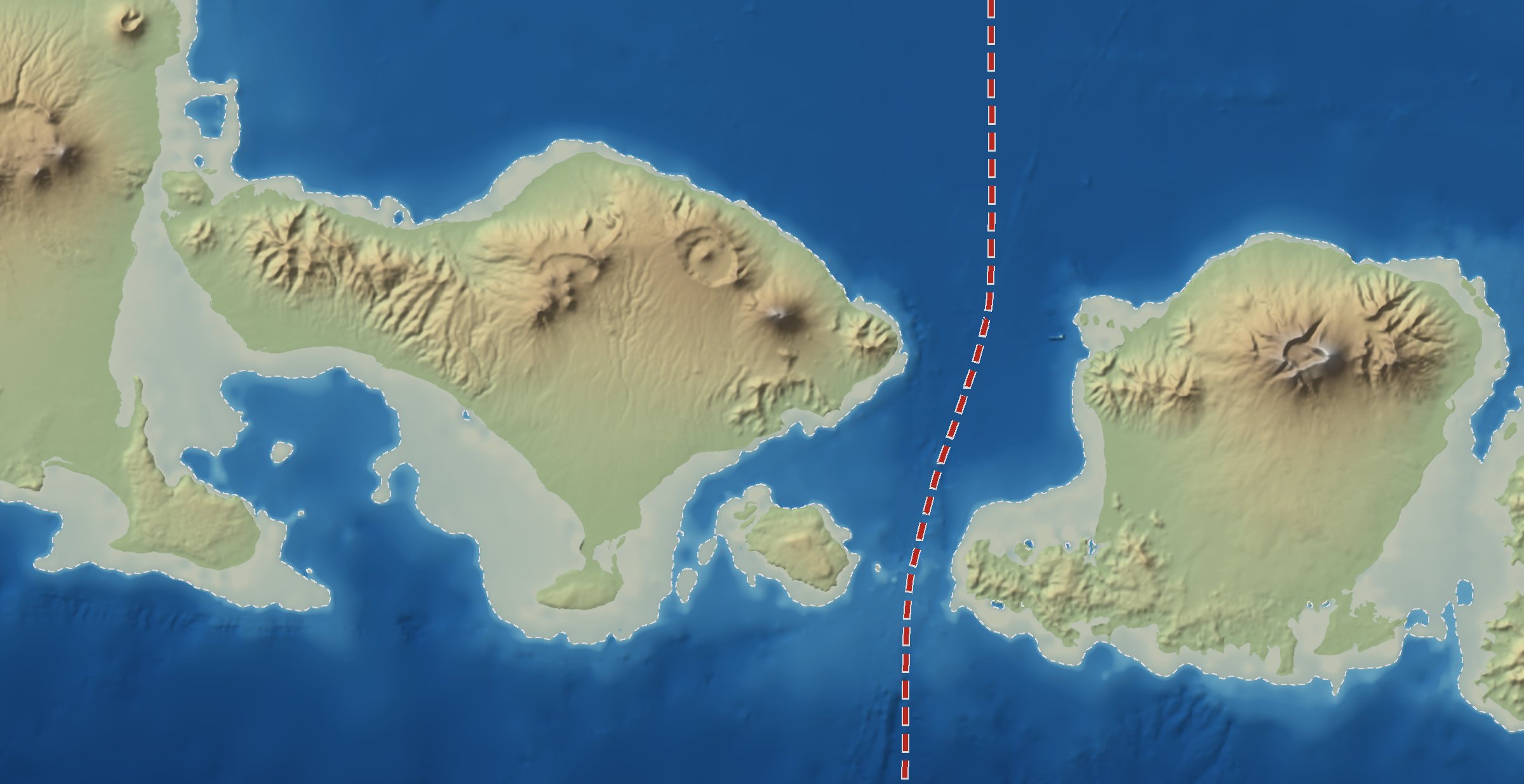
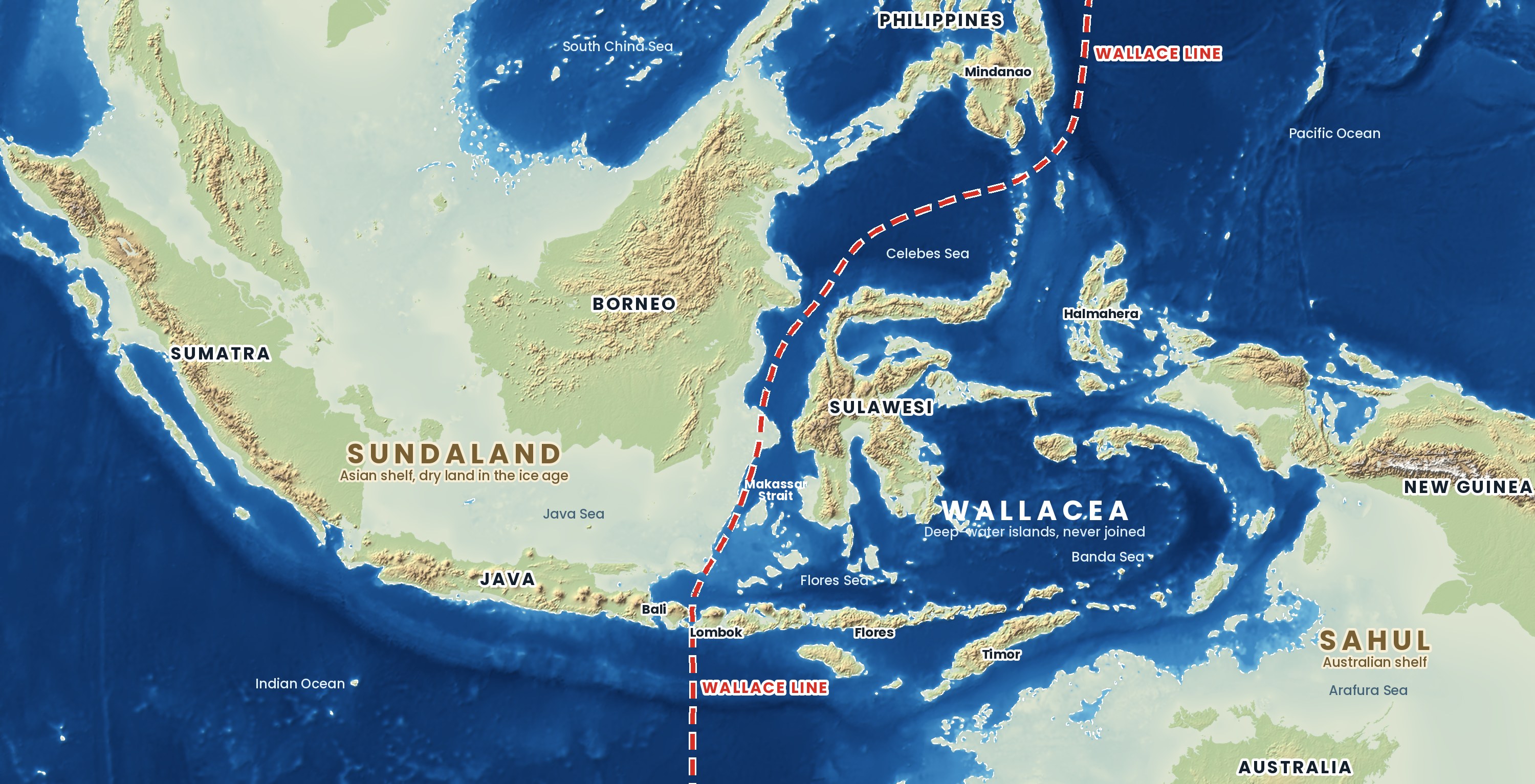
The Wallace Line is an invisible boundary through Indonesia that separates animals of Asian origin from those of Australian origin. It runs through the Lombok Strait between Bali and Lombok, then up the Makassar Strait between Borneo and Sulawesi. To the west live tigers, rhinos, orangutans and gibbons. To the east you start to meet cockatoos, honeyeaters and marsupials. For land mammals, freshwater fish and many birds it is one of the sharpest borders in nature, and it falls between two islands you can see from each other on a clear day.
Who was Alfred Russel Wallace?
A British naturalist who spent eight years in the islands of what is now Indonesia and Malaysia, from 1854 to 1862, and worked out the theory of evolution by natural selection independently of Charles Darwin. In 1856 he sailed from Bali to Lombok and was struck by the birds: the sulphur-crested cockatoo was common on Lombok but unknown on Bali, and Bali's barbets and woodpeckers had vanished. He drew the boundary on a map in 1859, and in 1868 the biologist Thomas Huxley named it "Wallace's Line". Wallace told the story in The Malay Archipelago (1869), still one of the great travel books.
Why don't animals cross the Wallace Line?
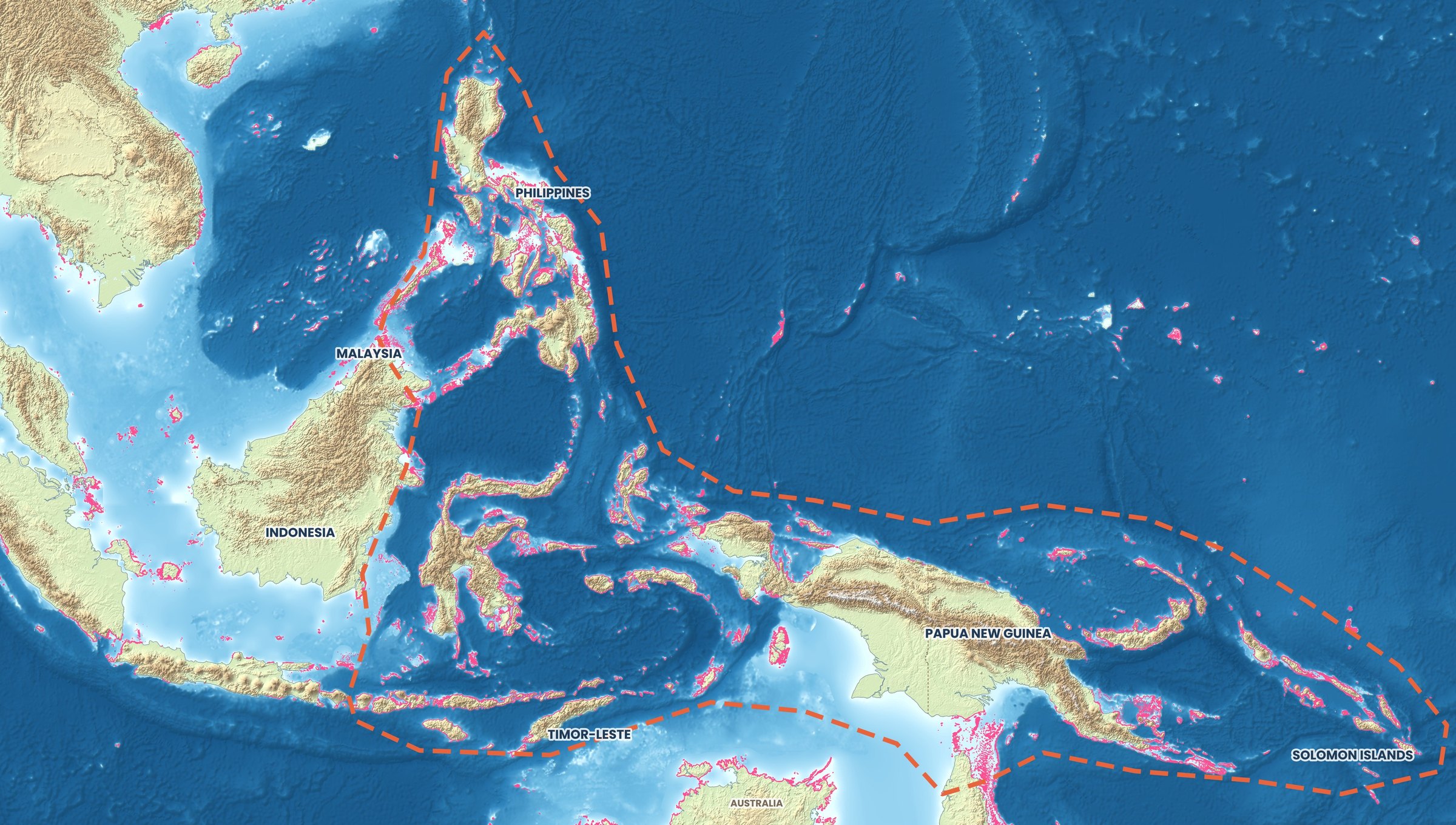
Because the water has always been too deep and too fast. In the ice ages, sea level fell by up to about 120 metres. Java, Bali, Sumatra and Borneo were joined to mainland Asia in one landmass, Sundaland, and tigers, elephants and rhinos could walk across it. The Lombok Strait is about 250 metres deep even at its shallowest point, so it never dried out, and Lombok stayed an island. Sulawesi, across the deep Makassar Strait, was never joined either. Australia and New Guinea formed their own landmass, Sahul, and the islands in between are known as Wallacea.
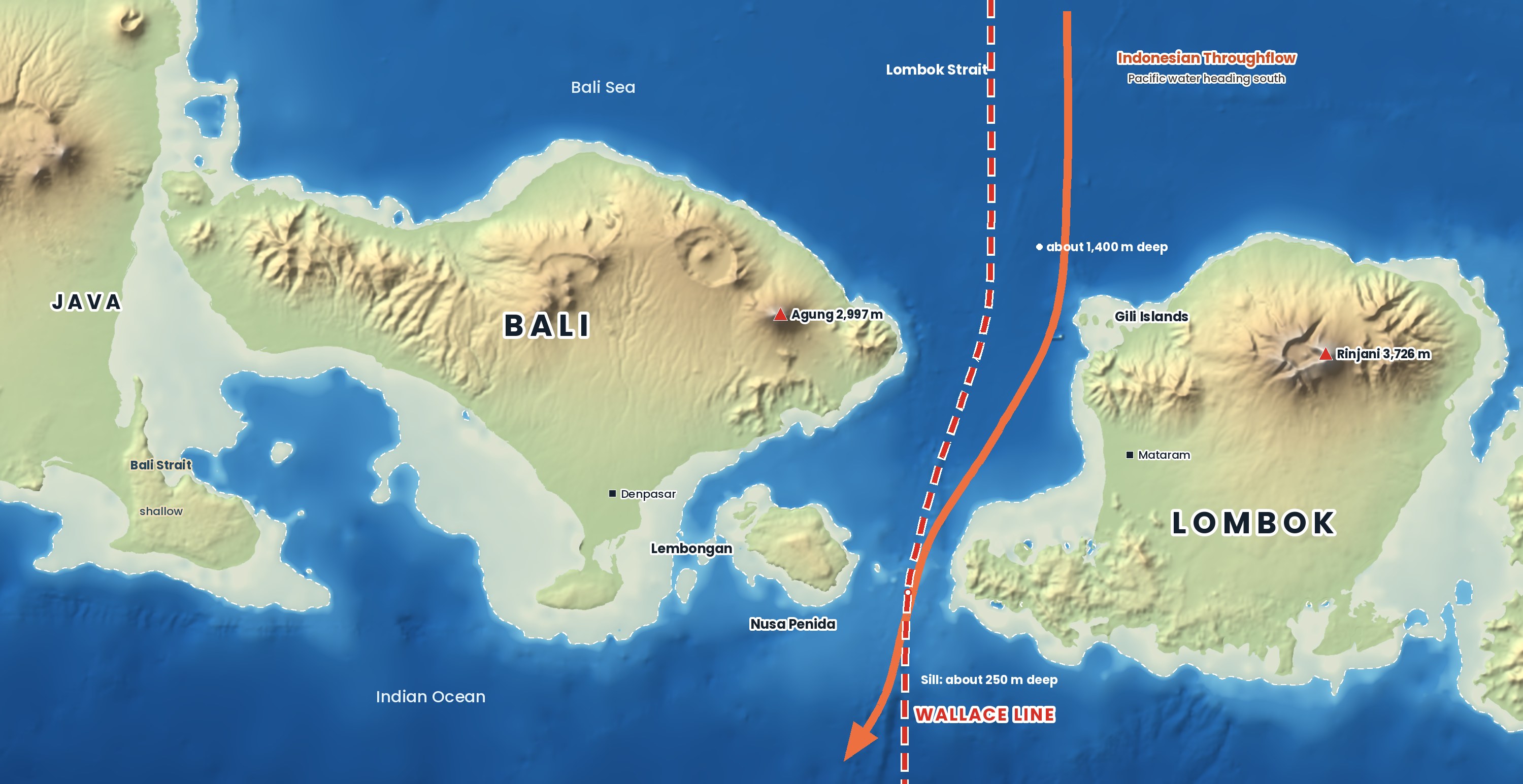
The strait is also one of the main exits of the Indonesian Throughflow, the current that carries Pacific water into the Indian Ocean: on average about 2.6 million cubic metres pour south through it every second, and tidal currents over the sill can top 3.5 metres per second. For an animal that cannot fly, 20 km of that water is almost impossible to cross. The few that made it, by swimming or rafting on floating vegetation, were cut off and evolved into species found nowhere else.
What lives on each side?
West of the line the wildlife is Asian: the Sumatran tiger, Sumatran and Javan rhinos, Asian elephants, orangutans and gibbons. Bali had its own tiger, but it is now extinct. East of the line the big Asian mammals disappear, and Wallacea has its own oddities: the anoa, a dwarf buffalo, and the babirusa, a pig with tusks that grow through its snout, both on Sulawesi, and the Komodo dragon on Komodo, Rinca and western Flores. Australian groups appear: cockatoos (Lombok marks their western limit), honeyeaters, megapodes and marsupial cuscuses. Further east, on New Guinea, come tree kangaroos and birds of paradise.
The line is not a fence. Bats and many birds fly across it, sea creatures swim through it, and people have carried cattle, pigs, dogs and deer across by boat. It shows most clearly in the wild animals of the forest.
Plants and a changing landscape
For plants the line is weak, because seeds travel on the wind, on birds and on the sea. Eucalyptus is one exception: the gum trees are native east of the line, and only the rainbow eucalyptus grows naturally as far west as Sulawesi and Mindanao. What you notice more as you travel east is the climate: the islands get drier towards Australia, and Bali's green rice terraces give way to the golden grassland of Komodo and Sumba in the dry season.
What the Wallace Line means underwater
For reef life, very little: corals, fish and turtles drift as larvae and spread freely, and both sides belong to the same Coral Triangle. What the deep strait brings is the ocean. From about July to October, cold water wells up along the edge of the strait around Nusa Penida, and below the thermocline divers report water as cold as about 17°C. It brings the oceanic sunfish, or mola mola, up to cleaning stations on the reef, with the best chances in August and September. Reef mantas visit all year. The same currents can turn into downcurrents without warning, so dive here only with an experienced local operator.
Great white sharks? Very rarely, if at all. Indonesia's only scientifically confirmed great white was a male of about 6 metres caught off Sumbawa in 2013. Divers reported one at Nusa Penida in 2019 and filmed one in March 2025, but neither sighting has been confirmed by scientists.
The first people to cross
Humans crossed by sea, and remarkably early. Flores, east of the line, was never joined to the mainland, yet its stone tools are at least a million years old, and it was home to Homo floresiensis, the small human nicknamed the "hobbit", until about 50,000 years ago. In January 2026 researchers reported a hand stencil about 67,800 years old on Muna, off Sulawesi, the oldest known rock art in the world: modern humans were island-hopping through Wallacea on their way to Australia.
How to see the Wallace Line for yourself
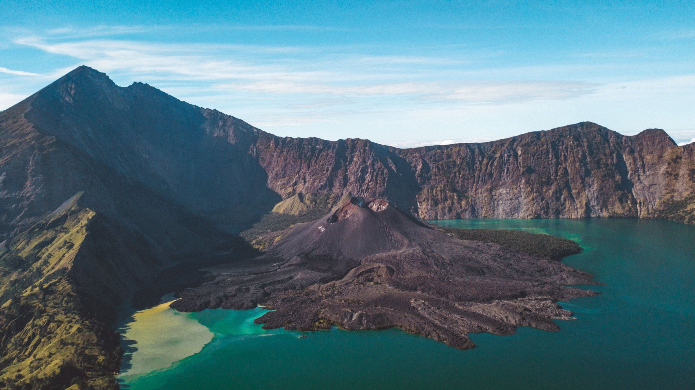
Cross it. The public ferry from Padang Bai on Bali to Lembar on Lombok takes several hours, and fast boats run to the Gili Islands and Lombok. Watch the water darken as the boat leaves the shelf, and feel the swell when it meets the current mid-strait; crossings can be rough, so check the forecast. Then compare the forest birds of West Bali National Park with those around Rinjani, or travel east to see Komodo dragons on Komodo and Rinca.
Quick answers
How deep is the Lombok Strait?
About 250 metres at its shallowest, at a sill near Nusa Penida, and around 1,400 metres in its northern part. It is about 20 km wide at its narrowest.
What is Wallacea?
The islands between the Asian and Australian continental shelves, including Sulawesi, Lombok, Flores and Timor, which were never joined to either continent.
What are Huxley's, Weber's and Lydekker's lines?
Later versions and neighbours of Wallace's boundary. Lydekker's Line marks the edge of the Australian shelf, Weber's the point where Asian and Australian animals are roughly equal; together they show the change is a broad zone, not a single line.
Are there great white sharks in Bali?
No confirmed ones. The only scientifically confirmed great white in Indonesia was caught off Sumbawa in 2013; diver sightings at Nusa Penida are unconfirmed.
Read more: the Indonesian Throughflow, Diving Bali, Lombok vs. Bali, and our Wildlife page.
Maps: terrain and bathymetry from NOAA ETOPO 2022, coastlines from GSHHG, drawn by Discover Indonesia. The ice-age shoreline is the present-day −120 m depth contour and is approximate.
Facts checked October 2026. Depths and current speeds are from published oceanographic studies and vary between sources. Sea conditions change quickly: always follow the advice of local boat and dive operators.
Sources
- Letter from Lombok, 21 August 1856 (A. R. Wallace, in The Zoologist, 1857; Wallace Online)
- The Malay Archipelago (A. R. Wallace, 1869; Project Gutenberg)
- Wallace in Singapore, 1854–1862 (Wallace Online)
- Wallace Line and Wallacea (Wikipedia)
- Oceanography surrounding Krakatau volcano and the Lombok Strait (Susanto et al. 2005, Oceanography)
- Makassar Strait throughflow, 2004 to 2006 (Gordon et al. 2008, Geophysical Research Letters)
- Indonesian Throughflow (Wikipedia; transport figures from Sprintall et al. 2009)
- Upwelling and sunfish sightings at Crystal Bay, Nusa Penida (IOP Conference Series: Earth and Environmental Science)
- Bali's mola diving (Divers Alert Network, Alert Diver)
- First confirmed record of the white shark from Indonesia (Fahmi & Dharmadi 2014, Marine Biodiversity Records)
- Great white shark makes rare Nusa Penida appearance (DIVE Magazine, 2025)
- Bali tiger (Wikipedia)
- New finds are clues to hobbit ancestry (University of Wollongong)
- Oldest known rock art found in an Indonesian cave (EarthSky, on the 2026 Nature paper)
- Maps: terrain and bathymetry NOAA ETOPO 2022; coastlines GSHHG; drawn by Discover Indonesia