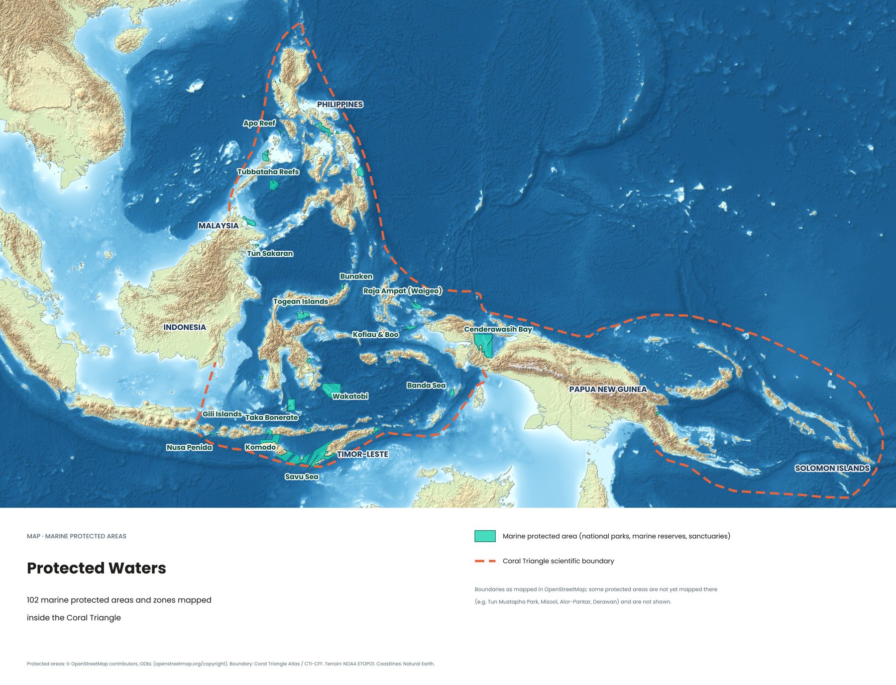
Some of the world's best dive sites are also some of its best-protected waters. This map shows 102 marine protected areas and zones mapped inside the Coral Triangle, and many of the names will look familiar to any diver.
The parks you'll know
- Raja Ampat, West PapuaThe region's most famous reefs, protected by a network of marine areas. Dive guide →
- Cenderawasih Bay, PapuaIndonesia's largest marine national park, known for whale sharks.
- Komodo National ParkDragons on land, mantas and currents underwater. Dive guide →
- Wakatobi National ParkFour islands and some of Indonesia's healthiest reefs. Dive guide →
- Taka BonerateOne of the largest atolls in the world. Dive guide →
- Bunaken, North SulawesiCoral walls just off Manado. Dive guide →
- Togean Islands, Banda Sea, Savu Sea, Gili Islands and Nusa PenidaSmaller and larger protected areas across eastern Indonesia.
- Tubbataha Reefs and Apo Reef, PhilippinesTwo of the Philippines' best-known protected reefs.
The map shows protected areas as recorded in OpenStreetMap. Some parks, such as Misool in Raja Ampat, Alor-Pantar, Derawan and Malaysia's Tun Mustapha Park, aren't mapped there yet and are missing from the map.
What protection means
Marine protected areas limit fishing, anchoring and development, either across the whole park or in specific zones. In the best-run parks, fish populations recover and spill over into surrounding waters, which helps local fishermen too.
Why your park fee matters
Most marine parks in Indonesia charge visitors an entry fee. It pays for rangers, patrol boats, mooring buoys that stop anchors damaging reefs, and community programmes. When you dive in a park, the fee is one of the most direct ways you help keep it the way you found it.
See all eight Coral Triangle maps →
Sources
- Protected areas © OpenStreetMap contributors, ODbL
- Boundary: Coral Triangle Atlas / CTI-CFF. Terrain: NOAA ETOPO1. Coastlines: Natural Earth